All the packages necessary to run are available, you shouldn't have to compile anything yourself with worldsynth.
The packages are listed here: http://www.mindwerks.net/2013/03/worlds ... -released/
I should probably post those on the main project page.
Python sadly isn't batteries included on windows... :/
Questions about the limits for landscape
Feedback on past, current, and future development.
-
psi29a

- Posts: 5361
- Joined: 29 Sep 2011, 10:13
- Location: Belgium
- Gitlab profile: https://gitlab.com/psi29a/
- Contact:

Re: Questions about the limits for landscape

https://www.flickr.com/photos/50822638@ ... 202803552/
would say that here is no height limit at least in common sense. rendering may still be dependant on viewing angle if the prop is some kilometer high .p
tesanwyn or the data creator would be good to have some smoothing option as the hills multiply in those heights.
hme gave flatter map and the result with scaling was better and that paint included is nice extra althought cannot generate textures itself.
with configurations in worldsynth the module depencies needs a bit honing. the pytables pro version is nowadays merged into free release and with 3.1.1 worldsynth doesn't start. the zigzag in smesh might be solved using the newer tesannwyn. tried to built with cygwin but gave "ld terminated with signal 11 segfault" in gnu libs the linker needs some update and "warning array supscript has type char" which is a compiler issue or the libraries was compiled on windows ?
may still work for flatter terrain yet.
here's the error report in first run. may be missing libraries
- Spoiler: Show
- $ make
cc tesannwyn.c -o tesannwyn -Wall -lm -s
In file included from tesannwyn.c:32:0:
common.c: In function ‘HumptyImage’:
common.c:215:8: warning: variable ‘lod_height’ set but not used [-Wunused-but-set-variable]
float lod_height[4225]; // An array containing the actual heights of each point in the cell. Turned in to a NIF later.
^
In file included from tesannwyn.c:33:0:
tes3_import.c: In function ‘ImportImage’:
tes3_import.c:222:5: warning: implicit declaration of function ‘WriteTES3LANDRecord’ [-Wimplicit-function-declaration]
WriteTES3LANDRecord(cx + opt_x_cell_offset, cy + opt_y_cell_offset, opt_adjust_height, &image, vclr_image, vtex_image, fp_out);
^
In file included from tesannwyn.c:34:0:
tes3_export.c: In function ‘Process3LANDData’:
tes3_export.c:310:4: warning: implicit declaration of function ‘StandardizeTES3VTEX’ [-Wimplicit-function-declaration]
StandardizeTES3VTEX(r + pos + 8, ntex);
^
In file included from tesannwyn.c:35:0:
tes3_vtex.c: In function ‘StringToReverseFormID’:
tes3_vtex.c:270:17: warning: array subscript has type ‘char’ [-Wchar-subscripts]
if (islower(htmp[0])) htmp[0] = toupper(htmp[0]);
^
tes3_vtex.c:270:17: warning: array subscript has type ‘char’ [-Wchar-subscripts]
tes3_vtex.c:271:17: warning: array subscript has type ‘char’ [-Wchar-subscripts]
if (islower(htmp[1])) htmp[1] = toupper(htmp[1]);
^
tes3_vtex.c:271:17: warning: array subscript has type ‘char’ [-Wchar-subscripts]
In file included from tesannwyn.c:37:0:
main.c: In function ‘main’:
main.c:37:6: warning: array subscript has type ‘char’ [-Wchar-subscripts]
if (isdigit(optarg[0])) {
^
In file included from tesannwyn.c:37:0:
main.c:292:3: warning: array subscript has type ‘char’ [-Wchar-subscripts]
if (isalpha(s[0]) && isalpha(s[1]) && isalpha(s[2]) && isalpha(s[3])) {
^
main.c:292:3: warning: array subscript has type ‘char’ [-Wchar-subscripts]
main.c:292:3: warning: array subscript has type ‘char’ [-Wchar-subscripts]
main.c:292:3: warning: array subscript has type ‘char’ [-Wchar-subscripts]
(edit: anyhow worked as same landmass with hme when did only dependency update to esp, something in the data structure.... worldsynth average evelation and landmass enabled also makes spikes. 52000 game units evelation.
yeah. something like that. with old tesannwyn gives (in 512, 1024, 4000) 16x16 cell land by 1024x1024 resolution. some algorithm settings causes the next error as didn't get it this time)
------
Code: Select all
getUint(mCtx.leftRec);
getUint(flags);// This header entry is always zero
getUint(flags);
mCtx.leftFile -= 12;

// Check that sizes add up
if (mCtx.leftFile < mCtx.leftRec)
fail("Record size is larger than rest of file");as for the what teaser likes the lightwave has been playing around a bit ,p
http://www.oceanlightwave.com/morrowind ... hot438.jpg
or these ones
http://www.oceanlightwave.com/morrowind/2x2/shot487.jpg
http://www.oceanlightwave.com/morrowind ... hot291.jpg
http://www.oceanlightwave.com/morrowind ... hot397.jpg
cannot really deside
Re: Questions about the limits for landscape


heh
just when these all get out in some years
http://www.shotn.com/forums/
http://forums.bethsoft.com/topic/145486 ... s-edition/
http://provincecyrodiil.project-tamriel ... .php?f=272
+ couple more
all bundling maybe to http://www.project-tamriel.com/
that's gonna be big map........... and game... all handcrafted........ o.O
Re: Questions about the limits for landscape
testing underway .p
for the limit it's depending how good your picture is if thoses spikes aren't coming from tesannwyn itself. which is probaply not wholly as it's has been tried and used and in certain ways it works slendidly. maybe with manual edit without so much color radiant ..
lightwave has bunch of applications http://www.oceanlightwave.com/morrowind/ for moving landskapes and admits this isn't the best piece of software what has wroten in readme.
as of static rendering over 3 cells and such not much tech savy but probaply need to wait still nearer with bug tracking and optimisation to 1.0 as http://www.ogre3d.org/2015/01/04/review ... -into-2015 changing to ogre 2.0 needs to be desided. there's most notably for this material system overhaul coming and changes to loaders. + bullet physics 3.0 nears it's completion althought gonna be majorly backward compatible. aaaaaaaaand jiggle bone for woman chests
in vanilla it's ca 32000 GU what makes in tesannwyn 456 m or from mountainous red mountain : )
https://www.flickr.com/photos/50822638@ ... 238165945/ yeah. would say it's bug and the high color radiant in hme. trying with flat pancake gives no problems


bigger height variance with h helps to tich those seams but it in high s height the program cut the landskape to pieces. around 40 worked what makes 1,15 km or 81900 GU
inside 54 000 it works good. would suggest that take the heighmap and modify it with some other program as the drawing tools are very small in hme. it goes for details better. worldsynt might also work this way
8-bit bmp can be modified in almost anything. gimp could do 16 bit and with few tricks 32 bit but if right from the oven it needs photoshop or some specialty program
edit:... gimp won't save the heigh map along as least traight from hme... code looks like could even understand in matter of weeks to pinpoint problems at least and relatively small one. http://bulletphysics.org/mediawiki-1.5. ... om_scratch this helped a lot for msvc what the heck situation.
for the limit it's depending how good your picture is if thoses spikes aren't coming from tesannwyn itself. which is probaply not wholly as it's has been tried and used and in certain ways it works slendidly. maybe with manual edit without so much color radiant ..
lightwave has bunch of applications http://www.oceanlightwave.com/morrowind/ for moving landskapes and admits this isn't the best piece of software what has wroten in readme.
as of static rendering over 3 cells and such not much tech savy but probaply need to wait still nearer with bug tracking and optimisation to 1.0 as http://www.ogre3d.org/2015/01/04/review ... -into-2015 changing to ogre 2.0 needs to be desided. there's most notably for this material system overhaul coming and changes to loaders. + bullet physics 3.0 nears it's completion althought gonna be majorly backward compatible. aaaaaaaaand jiggle bone for woman chests
in vanilla it's ca 32000 GU what makes in tesannwyn 456 m or from mountainous red mountain : )
https://www.flickr.com/photos/50822638@ ... 238165945/ yeah. would say it's bug and the high color radiant in hme. trying with flat pancake gives no problems
bigger height variance with h helps to tich those seams but it in high s height the program cut the landskape to pieces. around 40 worked what makes 1,15 km or 81900 GU
inside 54 000 it works good. would suggest that take the heighmap and modify it with some other program as the drawing tools are very small in hme. it goes for details better. worldsynt might also work this way
8-bit bmp can be modified in almost anything. gimp could do 16 bit and with few tricks 32 bit but if right from the oven it needs photoshop or some specialty program
edit:... gimp won't save the heigh map along as least traight from hme... code looks like could even understand in matter of weeks to pinpoint problems at least and relatively small one. http://bulletphysics.org/mediawiki-1.5. ... om_scratch this helped a lot for msvc what the heck situation.
Last edited by sjek on 14 Jan 2015, 18:46, edited 1 time in total.
-
silentthief

- Posts: 456
- Joined: 18 Apr 2013, 01:20
- Location: Currently traversing the Ascadian Isles
Re: Questions about the limits for landscape
Post by silentthief »
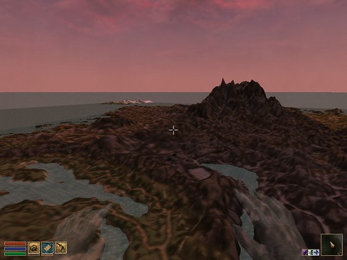
There are many things to consider when trying to not get "spikes" or torn landscape from an image. One image may show them at 1.0 scale and won't at say 0.5 or 0.25 scale. Spikes and torn landscape or other artifacts also show up if the BMP image is not the correct formatting (I think it was 8bit or 24bit)sjek wrote:testing underway .p
for the limit it's depending how good your picture is if thoses spikes aren't coming from tesannwyn itself. which is probaply not wholly as it's has been tried and used and in certain ways it works slendidly. maybe with manual edit without so much color radiant ..
lightwave has bunch of applications http://www.oceanlightwave.com/morrowind/ for moving landskapes and admits this isn't the best piece of software what has wroten in readme.
If you create a landscape in Gimp, then open it in HME and save it, this alone should save it as the properly formatted image file. I won't guarantee that this will always work, but I seem to remember that gimp won't use proper format no matter what way you save as.
As for moving landscape, you can set what cells the land goes to in TESAnnwyn, but I found that in trying to generate land this means you have to test is by running/flying/swimming your character to that location. I always made the land right at 0,0 to see it then moved it using tesfaith. Wish that this was much simpler.
That image shows a good example of the "torn landscape" where the morrowind engine either won't stretch the texture over too large of a distance or the data for the points is too far apart and it causes this artifact. I am not fully sure why this happens, but I know it is related to the distance between points - as lowering the scale in TESSAnnwyn will close these gaps.sjek wrote:
Just noticed that the "wilbur" page does not reolve... hmmm. I grabbed the wilbur executables as well as any documentation I could find on it a while ago. Not sure when the page went down.
I will see if I can give any more insight on the landscape stuff soon.
ST
-
psi29a
- Posts: 5361
- Joined: 29 Sep 2011, 10:13
- Location: Belgium
- Gitlab profile: https://gitlab.com/psi29a/
- Contact:
Re: Questions about the limits for landscape
The hight distance between two pixels are too extreme. I think that HME algo need to be fine-tuned a bit to give a more realistic landscape. You can always throw the BMP into gimp/photoshop and do smoothing/bluring of the heightmap. That should give more of a rolling effect instead of spikes.
Or just follow my instructions to install the libs and run worldsynth. I repeat, you shouldn't have to build anything.
Or just follow my instructions to install the libs and run worldsynth. I repeat, you shouldn't have to build anything.
Re: Questions about the limits for landscape
thing is that i have it 
It tells time to time that this version of pytables does not support indexing and in noise land option and the other one upper that modules is missing. Does it look for envirom variables .?
Then i try to use it in tesannwyn the height values go even without mountains to 2 or 3 km or so +/- and the adjacent cells are other on up and the other at nearer the bottom. Have to try to scale it down under 200m thought.
Problem is also inside cells that adjacent vertixes do the zigzag to x and/or y direction depending on picture formatting.
https://github.com/psi29a/TESAnnwyn/blo ... r/common.c might get this to build in msvc. Basically just need c edition of 2010 or any of newer ones and create empty win32 console application and load the codefiles. That should do it that there's no external dependencies. Then starting to comment some some calculations out.
Line 379 just looks suspicious... c book from library maybe
If that vex function calls for vertex colors that's on the trying list. Besides of raw or bmp checking on filename at least and getting the data out + error checks there seem to be no differentiating functions for data itself so it needs to be just right kind of file. As what comments go that takes the cells as one big array of numbers and then seems to bake it to esp format.
As of testing its kinda easy this time. The 10000000000 distand land setting isn't taking much on comp and it can be saved levitating near the spot without crashing the game. doing those maps with -x 60 setting currently
gimp + hme save works with minor seams and inverted heighmap ... making better one later

---------
edit: right link this time althought wizard island is kinda good reckon xP
and bumped into gimp image lua coding tutorials / handbook. http://pippin.gimp.org/image_processing/chap_dir.html ... something also in the image file it is as run-length encoding compression in gimp makes the ground all spiky
viewtopic.php?f=7&t=2301&start=10 --> previous page + 3d editing + github land search.. that's gonna be later case after esp record structure
this might take it's time anyhow. msvc tells outdated code and need to go those point by point with stackoverflow or some other or find older compiler. any idea with what version of C that was written .? ^^
ps. Microsoft Visual Studio 10.0\VC\include <-- this to include directories needed.
Simplest things first. needs to find equations what are used for those images and tweaking and comparing can be done with scilab 3d graphs. Then it's tweaking those to match and let's hope that terrain gonna be one piece or that c code has something to handle vertixes. There's external matrix libraries but dunno about those or better to look directly at openmw code and how the land coding is done. Would think that exporting command easy to keep but let's see how the code goes
Hme:
https://github.com/psi29a/worldsynth/bl ... acement.py
https://github.com/psi29a/worldsynth/bl ... ightmap.py
https://github.com/psi29a/worldsynth/bl ... th.py#L665
seems to generate kinda clean function. would say that export part needs possible tweaking
tesannwyn: ..... little bit harder
https://github.com/psi29a/TESAnnwyn/sea ... %93&q=Vhgt z coordinates are good place to start.
Edit: limit in vanilla comes from esp file 16 bit nature which only allows values up to that 32 657 or so.
viewtopic.php?f=3&t=1607&start=40#p25846
It tells time to time that this version of pytables does not support indexing and in noise land option and the other one upper that modules is missing. Does it look for envirom variables .?
Then i try to use it in tesannwyn the height values go even without mountains to 2 or 3 km or so +/- and the adjacent cells are other on up and the other at nearer the bottom. Have to try to scale it down under 200m thought.
Problem is also inside cells that adjacent vertixes do the zigzag to x and/or y direction depending on picture formatting.
https://github.com/psi29a/TESAnnwyn/blo ... r/common.c might get this to build in msvc. Basically just need c edition of 2010 or any of newer ones and create empty win32 console application and load the codefiles. That should do it that there's no external dependencies. Then starting to comment some some calculations out.
Code: Select all
if (opt_lod) {
lod_height[(ppc+1)*(i) + (j)] = (float) height * 8.0f - 8.0f; /If that vex function calls for vertex colors that's on the trying list. Besides of raw or bmp checking on filename at least and getting the data out + error checks there seem to be no differentiating functions for data itself so it needs to be just right kind of file. As what comments go that takes the cells as one big array of numbers and then seems to bake it to esp format.
As of testing its kinda easy this time. The 10000000000 distand land setting isn't taking much on comp and it can be saved levitating near the spot without crashing the game. doing those maps with -x 60 setting currently
gimp + hme save works with minor seams and inverted heighmap ... making better one later
---------
edit: right link this time althought wizard island is kinda good reckon xP
and bumped into gimp image lua coding tutorials / handbook. http://pippin.gimp.org/image_processing/chap_dir.html ... something also in the image file it is as run-length encoding compression in gimp makes the ground all spiky
viewtopic.php?f=7&t=2301&start=10 --> previous page + 3d editing + github land search.. that's gonna be later case after esp record structure
this might take it's time anyhow. msvc tells outdated code and need to go those point by point with stackoverflow or some other or find older compiler. any idea with what version of C that was written .? ^^
ps. Microsoft Visual Studio 10.0\VC\include <-- this to include directories needed.
- Spoiler: Show
- 1>------ Rebuild All started: Project: tesannwyn, Configuration: Debug Win32 ------
1> tesannwyn.c
1>e:\sdk\tesannwyn\common.c(19): warning C4996: 'sprintf': This function or variable may be unsafe. Consider using sprintf_s instead. To disable deprecation, use _CRT_SECURE_NO_WARNINGS. See online help for details.
1> e:\sdk\microsoft visual studio 10.0\vc\include\stdio.h(371) : see declaration of 'sprintf'
1>e:\sdk\tesannwyn\common.c(21): warning C4996: 'sprintf': This function or variable may be unsafe. Consider using sprintf_s instead. To disable deprecation, use _CRT_SECURE_NO_WARNINGS. See online help for details.
1> e:\sdk\microsoft visual studio 10.0\vc\include\stdio.h(371) : see declaration of 'sprintf'
1>e:\sdk\tesannwyn\common.c(23): warning C4996: 'sprintf': This function or variable may be unsafe. Consider using sprintf_s instead. To disable deprecation, use _CRT_SECURE_NO_WARNINGS. See online help for details.
1> e:\sdk\microsoft visual studio 10.0\vc\include\stdio.h(371) : see declaration of 'sprintf'
1>e:\sdk\tesannwyn\common.c(26): warning C4996: 'sprintf': This function or variable may be unsafe. Consider using sprintf_s instead. To disable deprecation, use _CRT_SECURE_NO_WARNINGS. See online help for details.
1> e:\sdk\microsoft visual studio 10.0\vc\include\stdio.h(371) : see declaration of 'sprintf'
1>e:\sdk\tesannwyn\common.c(33): warning C4996: 'sprintf': This function or variable may be unsafe. Consider using sprintf_s instead. To disable deprecation, use _CRT_SECURE_NO_WARNINGS. See online help for details.
1> e:\sdk\microsoft visual studio 10.0\vc\include\stdio.h(371) : see declaration of 'sprintf'
1>e:\sdk\tesannwyn\common.c(38): warning C4013: 'rmdir' undefined; assuming extern returning int
1>e:\sdk\tesannwyn\common.c(225): warning C4996: 'sprintf': This function or variable may be unsafe. Consider using sprintf_s instead. To disable deprecation, use _CRT_SECURE_NO_WARNINGS. See online help for details.
1> e:\sdk\microsoft visual studio 10.0\vc\include\stdio.h(371) : see declaration of 'sprintf'
1>e:\sdk\tesannwyn\common.c(226): warning C4013: 'mkdir' undefined; assuming extern returning int
1>e:\sdk\tesannwyn\common.c(227): warning C4996: 'sprintf': This function or variable may be unsafe. Consider using sprintf_s instead. To disable deprecation, use _CRT_SECURE_NO_WARNINGS. See online help for details.
1> e:\sdk\microsoft visual studio 10.0\vc\include\stdio.h(371) : see declaration of 'sprintf'
1>e:\sdk\tesannwyn\common.c(230): warning C4996: 'sprintf': This function or variable may be unsafe. Consider using sprintf_s instead. To disable deprecation, use _CRT_SECURE_NO_WARNINGS. See online help for details.
1> e:\sdk\microsoft visual studio 10.0\vc\include\stdio.h(371) : see declaration of 'sprintf'
1>e:\sdk\tesannwyn\common.c(238): warning C4996: 'fopen': This function or variable may be unsafe. Consider using fopen_s instead. To disable deprecation, use _CRT_SECURE_NO_WARNINGS. See online help for details.
1> e:\sdk\microsoft visual studio 10.0\vc\include\stdio.h(234) : see declaration of 'fopen'
1>e:\sdk\tesannwyn\common.c(240): warning C4996: 'strerror': This function or variable may be unsafe. Consider using strerror_s instead. To disable deprecation, use _CRT_SECURE_NO_WARNINGS. See online help for details.
1> e:\sdk\microsoft visual studio 10.0\vc\include\string.h(157) : see declaration of 'strerror'
1>e:\sdk\tesannwyn\common.c(273): warning C4996: 'sprintf': This function or variable may be unsafe. Consider using sprintf_s instead. To disable deprecation, use _CRT_SECURE_NO_WARNINGS. See online help for details.
1> e:\sdk\microsoft visual studio 10.0\vc\include\stdio.h(371) : see declaration of 'sprintf'
1>e:\sdk\tesannwyn\common.c(274): warning C4996: 'fopen': This function or variable may be unsafe. Consider using fopen_s instead. To disable deprecation, use _CRT_SECURE_NO_WARNINGS. See online help for details.
1> e:\sdk\microsoft visual studio 10.0\vc\include\stdio.h(234) : see declaration of 'fopen'
1>e:\sdk\tesannwyn\common.c(321): warning C4244: '=' : conversion from 'int' to 'float', possible loss of data
1>e:\sdk\tesannwyn\common.c(470): warning C4996: 'sprintf': This function or variable may be unsafe. Consider using sprintf_s instead. To disable deprecation, use _CRT_SECURE_NO_WARNINGS. See online help for details.
1> e:\sdk\microsoft visual studio 10.0\vc\include\stdio.h(371) : see declaration of 'sprintf'
1>e:\sdk\tesannwyn\common.c(471): warning C4996: 'fopen': This function or variable may be unsafe. Consider using fopen_s instead. To disable deprecation, use _CRT_SECURE_NO_WARNINGS. See online help for details.
1> e:\sdk\microsoft visual studio 10.0\vc\include\stdio.h(234) : see declaration of 'fopen'
1>e:\sdk\tesannwyn\common.c(492): warning C4244: '=' : conversion from 'float' to 'int', possible loss of data
1>e:\sdk\tesannwyn\common.c(535): warning C4996: 'strerror': This function or variable may be unsafe. Consider using strerror_s instead. To disable deprecation, use _CRT_SECURE_NO_WARNINGS. See online help for details.
1> e:\sdk\microsoft visual studio 10.0\vc\include\string.h(157) : see declaration of 'strerror'
1>e:\sdk\tesannwyn\common.c(542): warning C4996: 'fopen': This function or variable may be unsafe. Consider using fopen_s instead. To disable deprecation, use _CRT_SECURE_NO_WARNINGS. See online help for details.
1> e:\sdk\microsoft visual studio 10.0\vc\include\stdio.h(234) : see declaration of 'fopen'
1>e:\sdk\tesannwyn\common.c(544): warning C4996: 'strerror': This function or variable may be unsafe. Consider using strerror_s instead. To disable deprecation, use _CRT_SECURE_NO_WARNINGS. See online help for details.
1> e:\sdk\microsoft visual studio 10.0\vc\include\string.h(157) : see declaration of 'strerror'
1>e:\sdk\tesannwyn\common.c(577): warning C4996: 'fopen': This function or variable may be unsafe. Consider using fopen_s instead. To disable deprecation, use _CRT_SECURE_NO_WARNINGS. See online help for details.
1> e:\sdk\microsoft visual studio 10.0\vc\include\stdio.h(234) : see declaration of 'fopen'
1>e:\sdk\tesannwyn\common.c(579): warning C4996: 'strerror': This function or variable may be unsafe. Consider using strerror_s instead. To disable deprecation, use _CRT_SECURE_NO_WARNINGS. See online help for details.
1> e:\sdk\microsoft visual studio 10.0\vc\include\string.h(157) : see declaration of 'strerror'
1>e:\sdk\tesannwyn\common.c(598): warning C4996: 'sprintf': This function or variable may be unsafe. Consider using sprintf_s instead. To disable deprecation, use _CRT_SECURE_NO_WARNINGS. See online help for details.
1> e:\sdk\microsoft visual studio 10.0\vc\include\stdio.h(371) : see declaration of 'sprintf'
1>e:\sdk\tesannwyn\common.c(599): warning C4996: 'fopen': This function or variable may be unsafe. Consider using fopen_s instead. To disable deprecation, use _CRT_SECURE_NO_WARNINGS. See online help for details.
1> e:\sdk\microsoft visual studio 10.0\vc\include\stdio.h(234) : see declaration of 'fopen'
1>e:\sdk\tesannwyn\common.c(678): warning C4996: 'fopen': This function or variable may be unsafe. Consider using fopen_s instead. To disable deprecation, use _CRT_SECURE_NO_WARNINGS. See online help for details.
1> e:\sdk\microsoft visual studio 10.0\vc\include\stdio.h(234) : see declaration of 'fopen'
1>e:\sdk\tesannwyn\common.c(680): warning C4996: 'strerror': This function or variable may be unsafe. Consider using strerror_s instead. To disable deprecation, use _CRT_SECURE_NO_WARNINGS. See online help for details.
1> e:\sdk\microsoft visual studio 10.0\vc\include\string.h(157) : see declaration of 'strerror'
1>e:\sdk\tesannwyn\common.c(713): warning C4996: 'sprintf': This function or variable may be unsafe. Consider using sprintf_s instead. To disable deprecation, use _CRT_SECURE_NO_WARNINGS. See online help for details.
1> e:\sdk\microsoft visual studio 10.0\vc\include\stdio.h(371) : see declaration of 'sprintf'
1>e:\sdk\tesannwyn\common.c(715): warning C4996: 'sprintf': This function or variable may be unsafe. Consider using sprintf_s instead. To disable deprecation, use _CRT_SECURE_NO_WARNINGS. See online help for details.
1> e:\sdk\microsoft visual studio 10.0\vc\include\stdio.h(371) : see declaration of 'sprintf'
1>e:\sdk\tesannwyn\common.c(718): warning C4996: 'fopen': This function or variable may be unsafe. Consider using fopen_s instead. To disable deprecation, use _CRT_SECURE_NO_WARNINGS. See online help for details.
1> e:\sdk\microsoft visual studio 10.0\vc\include\stdio.h(234) : see declaration of 'fopen'
1>e:\sdk\tesannwyn\common.c(750): warning C4996: 'fopen': This function or variable may be unsafe. Consider using fopen_s instead. To disable deprecation, use _CRT_SECURE_NO_WARNINGS. See online help for details.
1> e:\sdk\microsoft visual studio 10.0\vc\include\stdio.h(234) : see declaration of 'fopen'
1>e:\sdk\tesannwyn\common.c(752): warning C4996: 'strerror': This function or variable may be unsafe. Consider using strerror_s instead. To disable deprecation, use _CRT_SECURE_NO_WARNINGS. See online help for details.
1> e:\sdk\microsoft visual studio 10.0\vc\include\string.h(157) : see declaration of 'strerror'
1>e:\sdk\tesannwyn\tes3_import.c(83): warning C4996: 'fopen': This function or variable may be unsafe. Consider using fopen_s instead. To disable deprecation, use _CRT_SECURE_NO_WARNINGS. See online help for details.
1> e:\sdk\microsoft visual studio 10.0\vc\include\stdio.h(234) : see declaration of 'fopen'
1>e:\sdk\tesannwyn\tes3_import.c(85): warning C4996: 'strerror': This function or variable may be unsafe. Consider using strerror_s instead. To disable deprecation, use _CRT_SECURE_NO_WARNINGS. See online help for details.
1> e:\sdk\microsoft visual studio 10.0\vc\include\string.h(157) : see declaration of 'strerror'
1>e:\sdk\tesannwyn\tes3_import.c(99): warning C4996: 'fopen': This function or variable may be unsafe. Consider using fopen_s instead. To disable deprecation, use _CRT_SECURE_NO_WARNINGS. See online help for details.
1> e:\sdk\microsoft visual studio 10.0\vc\include\stdio.h(234) : see declaration of 'fopen'
1>e:\sdk\tesannwyn\tes3_import.c(101): warning C4996: 'strerror': This function or variable may be unsafe. Consider using strerror_s instead. To disable deprecation, use _CRT_SECURE_NO_WARNINGS. See online help for details.
1> e:\sdk\microsoft visual studio 10.0\vc\include\string.h(157) : see declaration of 'strerror'
1>e:\sdk\tesannwyn\tes3_import.c(106): warning C4996: 'fopen': This function or variable may be unsafe. Consider using fopen_s instead. To disable deprecation, use _CRT_SECURE_NO_WARNINGS. See online help for details.
1> e:\sdk\microsoft visual studio 10.0\vc\include\stdio.h(234) : see declaration of 'fopen'
1>e:\sdk\tesannwyn\tes3_import.c(109): warning C4996: 'strerror': This function or variable may be unsafe. Consider using strerror_s instead. To disable deprecation, use _CRT_SECURE_NO_WARNINGS. See online help for details.
1> e:\sdk\microsoft visual studio 10.0\vc\include\string.h(157) : see declaration of 'strerror'
1>e:\sdk\tesannwyn\tes3_import.c(115): warning C4996: 'fopen': This function or variable may be unsafe. Consider using fopen_s instead. To disable deprecation, use _CRT_SECURE_NO_WARNINGS. See online help for details.
1> e:\sdk\microsoft visual studio 10.0\vc\include\stdio.h(234) : see declaration of 'fopen'
1>e:\sdk\tesannwyn\tes3_import.c(117): warning C4996: 'strerror': This function or variable may be unsafe. Consider using strerror_s instead. To disable deprecation, use _CRT_SECURE_NO_WARNINGS. See online help for details.
1> e:\sdk\microsoft visual studio 10.0\vc\include\string.h(157) : see declaration of 'strerror'
1>e:\sdk\tesannwyn\tes3_import.c(186): warning C4244: '*=' : conversion from 'double' to 'int', possible loss of data
1>e:\sdk\tesannwyn\tes3_import.c(222): warning C4013: 'WriteTES3LANDRecord' undefined; assuming extern returning int
1>e:\sdk\tesannwyn\tes3_import.c(240): warning C4996: 'unlink': The POSIX name for this item is deprecated. Instead, use the ISO C++ conformant name: _unlink. See online help for details.
1> e:\sdk\microsoft visual studio 10.0\vc\include\stdio.h(299) : see declaration of 'unlink'
1>e:\sdk\tesannwyn\tes3_import.c(241): warning C4996: 'unlink': The POSIX name for this item is deprecated. Instead, use the ISO C++ conformant name: _unlink. See online help for details.
1> e:\sdk\microsoft visual studio 10.0\vc\include\stdio.h(299) : see declaration of 'unlink'
1>e:\sdk\tesannwyn\tes3_import.c(356): warning C4244: '=' : conversion from 'int' to 'float', possible loss of data
1>e:\sdk\tesannwyn\tes3_import.c(360): warning C4244: '=' : conversion from 'int' to 'float', possible loss of data
1>e:\sdk\tesannwyn\tes3_import.c(366): warning C4244: '=' : conversion from 'double' to 'float', possible loss of data
1>e:\sdk\tesannwyn\tes3_import.c(466): warning C4996: 'fopen': This function or variable may be unsafe. Consider using fopen_s instead. To disable deprecation, use _CRT_SECURE_NO_WARNINGS. See online help for details.
1> e:\sdk\microsoft visual studio 10.0\vc\include\stdio.h(234) : see declaration of 'fopen'
1>e:\sdk\tesannwyn\tes3_import.c(491): warning C4996: 'strerror': This function or variable may be unsafe. Consider using strerror_s instead. To disable deprecation, use _CRT_SECURE_NO_WARNINGS. See online help for details.
1> e:\sdk\microsoft visual studio 10.0\vc\include\string.h(157) : see declaration of 'strerror'
1>e:\sdk\tesannwyn\tes3_import.c(495): warning C4996: 'strcpy': This function or variable may be unsafe. Consider using strcpy_s instead. To disable deprecation, use _CRT_SECURE_NO_WARNINGS. See online help for details.
1> e:\sdk\microsoft visual studio 10.0\vc\include\string.h(105) : see declaration of 'strcpy'
1>e:\sdk\tesannwyn\tes3_import.c(608): warning C4996: 'fopen': This function or variable may be unsafe. Consider using fopen_s instead. To disable deprecation, use _CRT_SECURE_NO_WARNINGS. See online help for details.
1> e:\sdk\microsoft visual studio 10.0\vc\include\stdio.h(234) : see declaration of 'fopen'
1>e:\sdk\tesannwyn\tes3_import.c(610): warning C4996: 'strerror': This function or variable may be unsafe. Consider using strerror_s instead. To disable deprecation, use _CRT_SECURE_NO_WARNINGS. See online help for details.
1> e:\sdk\microsoft visual studio 10.0\vc\include\string.h(157) : see declaration of 'strerror'
1>e:\sdk\tesannwyn\tes3_import.c(613): warning C4996: 'fopen': This function or variable may be unsafe. Consider using fopen_s instead. To disable deprecation, use _CRT_SECURE_NO_WARNINGS. See online help for details.
1> e:\sdk\microsoft visual studio 10.0\vc\include\stdio.h(234) : see declaration of 'fopen'
1>e:\sdk\tesannwyn\tes3_import.c(615): warning C4996: 'strerror': This function or variable may be unsafe. Consider using strerror_s instead. To disable deprecation, use _CRT_SECURE_NO_WARNINGS. See online help for details.
1> e:\sdk\microsoft visual studio 10.0\vc\include\string.h(157) : see declaration of 'strerror'
1>e:\sdk\tesannwyn\tes3_import.c(694): warning C4996: 'fopen': This function or variable may be unsafe. Consider using fopen_s instead. To disable deprecation, use _CRT_SECURE_NO_WARNINGS. See online help for details.
1> e:\sdk\microsoft visual studio 10.0\vc\include\stdio.h(234) : see declaration of 'fopen'
1>e:\sdk\tesannwyn\tes3_import.c(696): warning C4996: 'strerror': This function or variable may be unsafe. Consider using strerror_s instead. To disable deprecation, use _CRT_SECURE_NO_WARNINGS. See online help for details.
1> e:\sdk\microsoft visual studio 10.0\vc\include\string.h(157) : see declaration of 'strerror'
1>e:\sdk\tesannwyn\tes3_import.c(729): warning C4996: 'fopen': This function or variable may be unsafe. Consider using fopen_s instead. To disable deprecation, use _CRT_SECURE_NO_WARNINGS. See online help for details.
1> e:\sdk\microsoft visual studio 10.0\vc\include\stdio.h(234) : see declaration of 'fopen'
1>e:\sdk\tesannwyn\tes3_import.c(731): warning C4996: 'strerror': This function or variable may be unsafe. Consider using strerror_s instead. To disable deprecation, use _CRT_SECURE_NO_WARNINGS. See online help for details.
1> e:\sdk\microsoft visual studio 10.0\vc\include\string.h(157) : see declaration of 'strerror'
1>e:\sdk\tesannwyn\tes3_import.c(798): warning C4996: 'fopen': This function or variable may be unsafe. Consider using fopen_s instead. To disable deprecation, use _CRT_SECURE_NO_WARNINGS. See online help for details.
1> e:\sdk\microsoft visual studio 10.0\vc\include\stdio.h(234) : see declaration of 'fopen'
1>e:\sdk\tesannwyn\tes3_import.c(833): warning C4996: 'strerror': This function or variable may be unsafe. Consider using strerror_s instead. To disable deprecation, use _CRT_SECURE_NO_WARNINGS. See online help for details.
1> e:\sdk\microsoft visual studio 10.0\vc\include\string.h(157) : see declaration of 'strerror'
1>e:\sdk\tesannwyn\tes3_export.c(38): warning C4996: 'sprintf': This function or variable may be unsafe. Consider using sprintf_s instead. To disable deprecation, use _CRT_SECURE_NO_WARNINGS. See online help for details.
1> e:\sdk\microsoft visual studio 10.0\vc\include\stdio.h(371) : see declaration of 'sprintf'
1>e:\sdk\tesannwyn\tes3_export.c(40): warning C4996: 'unlink': The POSIX name for this item is deprecated. Instead, use the ISO C++ conformant name: _unlink. See online help for details.
1> e:\sdk\microsoft visual studio 10.0\vc\include\stdio.h(299) : see declaration of 'unlink'
1>e:\sdk\tesannwyn\tes3_export.c(45): warning C4996: 'sprintf': This function or variable may be unsafe. Consider using sprintf_s instead. To disable deprecation, use _CRT_SECURE_NO_WARNINGS. See online help for details.
1> e:\sdk\microsoft visual studio 10.0\vc\include\stdio.h(371) : see declaration of 'sprintf'
1>e:\sdk\tesannwyn\tes3_export.c(53): warning C4996: 'unlink': The POSIX name for this item is deprecated. Instead, use the ISO C++ conformant name: _unlink. See online help for details.
1> e:\sdk\microsoft visual studio 10.0\vc\include\stdio.h(299) : see declaration of 'unlink'
1>e:\sdk\tesannwyn\tes3_export.c(54): warning C4996: 'unlink': The POSIX name for this item is deprecated. Instead, use the ISO C++ conformant name: _unlink. See online help for details.
1> e:\sdk\microsoft visual studio 10.0\vc\include\stdio.h(299) : see declaration of 'unlink'
1>e:\sdk\tesannwyn\tes3_export.c(55): warning C4996: 'sprintf': This function or variable may be unsafe. Consider using sprintf_s instead. To disable deprecation, use _CRT_SECURE_NO_WARNINGS. See online help for details.
1> e:\sdk\microsoft visual studio 10.0\vc\include\stdio.h(371) : see declaration of 'sprintf'
1>e:\sdk\tesannwyn\tes3_export.c(56): warning C4996: 'unlink': The POSIX name for this item is deprecated. Instead, use the ISO C++ conformant name: _unlink. See online help for details.
1> e:\sdk\microsoft visual studio 10.0\vc\include\stdio.h(299) : see declaration of 'unlink'
1>e:\sdk\tesannwyn\tes3_export.c(80): warning C4996: 'sprintf': This function or variable may be unsafe. Consider using sprintf_s instead. To disable deprecation, use _CRT_SECURE_NO_WARNINGS. See online help for details.
1> e:\sdk\microsoft visual studio 10.0\vc\include\stdio.h(371) : see declaration of 'sprintf'
1>e:\sdk\tesannwyn\tes3_export.c(139): warning C4996: 'fopen': This function or variable may be unsafe. Consider using fopen_s instead. To disable deprecation, use _CRT_SECURE_NO_WARNINGS. See online help for details.
1> e:\sdk\microsoft visual studio 10.0\vc\include\stdio.h(234) : see declaration of 'fopen'
1>e:\sdk\tesannwyn\tes3_export.c(141): warning C4996: 'strerror': This function or variable may be unsafe. Consider using strerror_s instead. To disable deprecation, use _CRT_SECURE_NO_WARNINGS. See online help for details.
1> e:\sdk\microsoft visual studio 10.0\vc\include\string.h(157) : see declaration of 'strerror'
1>e:\sdk\tesannwyn\tes3_export.c(169): warning C4996: 'strerror': This function or variable may be unsafe. Consider using strerror_s instead. To disable deprecation, use _CRT_SECURE_NO_WARNINGS. See online help for details.
1> e:\sdk\microsoft visual studio 10.0\vc\include\string.h(157) : see declaration of 'strerror'
1>e:\sdk\tesannwyn\tes3_export.c(175): warning C4018: '<' : signed/unsigned mismatch
1>e:\sdk\tesannwyn\tes3_export.c(178): warning C4996: 'strerror': This function or variable may be unsafe. Consider using strerror_s instead. To disable deprecation, use _CRT_SECURE_NO_WARNINGS. See online help for details.
1> e:\sdk\microsoft visual studio 10.0\vc\include\string.h(157) : see declaration of 'strerror'
1>e:\sdk\tesannwyn\tes3_export.c(207): warning C4996: 'unlink': The POSIX name for this item is deprecated. Instead, use the ISO C++ conformant name: _unlink. See online help for details.
1> e:\sdk\microsoft visual studio 10.0\vc\include\stdio.h(299) : see declaration of 'unlink'
1>e:\sdk\tesannwyn\tes3_export.c(265): warning C4996: 'sprintf': This function or variable may be unsafe. Consider using sprintf_s instead. To disable deprecation, use _CRT_SECURE_NO_WARNINGS. See online help for details.
1> e:\sdk\microsoft visual studio 10.0\vc\include\stdio.h(371) : see declaration of 'sprintf'
1>e:\sdk\tesannwyn\tes3_export.c(267): warning C4996: 'fopen': This function or variable may be unsafe. Consider using fopen_s instead. To disable deprecation, use _CRT_SECURE_NO_WARNINGS. See online help for details.
1> e:\sdk\microsoft visual studio 10.0\vc\include\stdio.h(234) : see declaration of 'fopen'
1>e:\sdk\tesannwyn\tes3_export.c(269): warning C4996: 'strerror': This function or variable may be unsafe. Consider using strerror_s instead. To disable deprecation, use _CRT_SECURE_NO_WARNINGS. See online help for details.
1> e:\sdk\microsoft visual studio 10.0\vc\include\string.h(157) : see declaration of 'strerror'
1>e:\sdk\tesannwyn\tes3_export.c(285): warning C4996: 'sprintf': This function or variable may be unsafe. Consider using sprintf_s instead. To disable deprecation, use _CRT_SECURE_NO_WARNINGS. See online help for details.
1> e:\sdk\microsoft visual studio 10.0\vc\include\stdio.h(371) : see declaration of 'sprintf'
1>e:\sdk\tesannwyn\tes3_export.c(287): warning C4996: 'fopen': This function or variable may be unsafe. Consider using fopen_s instead. To disable deprecation, use _CRT_SECURE_NO_WARNINGS. See online help for details.
1> e:\sdk\microsoft visual studio 10.0\vc\include\stdio.h(234) : see declaration of 'fopen'
1>e:\sdk\tesannwyn\tes3_export.c(289): warning C4996: 'strerror': This function or variable may be unsafe. Consider using strerror_s instead. To disable deprecation, use _CRT_SECURE_NO_WARNINGS. See online help for details.
1> e:\sdk\microsoft visual studio 10.0\vc\include\string.h(157) : see declaration of 'strerror'
1>e:\sdk\tesannwyn\tes3_export.c(297): warning C4996: 'sprintf': This function or variable may be unsafe. Consider using sprintf_s instead. To disable deprecation, use _CRT_SECURE_NO_WARNINGS. See online help for details.
1> e:\sdk\microsoft visual studio 10.0\vc\include\stdio.h(371) : see declaration of 'sprintf'
1>e:\sdk\tesannwyn\tes3_export.c(299): warning C4996: 'fopen': This function or variable may be unsafe. Consider using fopen_s instead. To disable deprecation, use _CRT_SECURE_NO_WARNINGS. See online help for details.
1> e:\sdk\microsoft visual studio 10.0\vc\include\stdio.h(234) : see declaration of 'fopen'
1>e:\sdk\tesannwyn\tes3_export.c(301): warning C4996: 'strerror': This function or variable may be unsafe. Consider using strerror_s instead. To disable deprecation, use _CRT_SECURE_NO_WARNINGS. See online help for details.
1> e:\sdk\microsoft visual studio 10.0\vc\include\string.h(157) : see declaration of 'strerror'
1>e:\sdk\tesannwyn\tes3_export.c(310): warning C4013: 'StandardizeTES3VTEX' undefined; assuming extern returning int
1>e:\sdk\tesannwyn\tes3_export.c(343): warning C4244: '=' : conversion from 'unsigned short' to 'char', possible loss of data
1>e:\sdk\tesannwyn\tes3_export.c(432): warning C4996: 'fopen': This function or variable may be unsafe. Consider using fopen_s instead. To disable deprecation, use _CRT_SECURE_NO_WARNINGS. See online help for details.
1> e:\sdk\microsoft visual studio 10.0\vc\include\stdio.h(234) : see declaration of 'fopen'
1>e:\sdk\tesannwyn\tes3_export.c(434): warning C4996: 'strerror': This function or variable may be unsafe. Consider using strerror_s instead. To disable deprecation, use _CRT_SECURE_NO_WARNINGS. See online help for details.
1> e:\sdk\microsoft visual studio 10.0\vc\include\string.h(157) : see declaration of 'strerror'
1>e:\sdk\tesannwyn\tes3_vtex.c(29): warning C4996: 'strncpy': This function or variable may be unsafe. Consider using strncpy_s instead. To disable deprecation, use _CRT_SECURE_NO_WARNINGS. See online help for details.
1> e:\sdk\microsoft visual studio 10.0\vc\include\string.h(188) : see declaration of 'strncpy'
1>e:\sdk\tesannwyn\tes3_vtex.c(41): warning C4996: 'strncpy': This function or variable may be unsafe. Consider using strncpy_s instead. To disable deprecation, use _CRT_SECURE_NO_WARNINGS. See online help for details.
1> e:\sdk\microsoft visual studio 10.0\vc\include\string.h(188) : see declaration of 'strncpy'
1>e:\sdk\tesannwyn\tes3_vtex.c(90): warning C4996: 'fopen': This function or variable may be unsafe. Consider using fopen_s instead. To disable deprecation, use _CRT_SECURE_NO_WARNINGS. See online help for details.
1> e:\sdk\microsoft visual studio 10.0\vc\include\stdio.h(234) : see declaration of 'fopen'
1>e:\sdk\tesannwyn\tes3_vtex.c(115): warning C4996: 'strerror': This function or variable may be unsafe. Consider using strerror_s instead. To disable deprecation, use _CRT_SECURE_NO_WARNINGS. See online help for details.
1> e:\sdk\microsoft visual studio 10.0\vc\include\string.h(157) : see declaration of 'strerror'
1>e:\sdk\tesannwyn\tes3_vtex.c(200): warning C4996: 'sprintf': This function or variable may be unsafe. Consider using sprintf_s instead. To disable deprecation, use _CRT_SECURE_NO_WARNINGS. See online help for details.
1> e:\sdk\microsoft visual studio 10.0\vc\include\stdio.h(371) : see declaration of 'sprintf'
1>e:\sdk\tesannwyn\tes3_vtex.c(204): warning C4996: 'sprintf': This function or variable may be unsafe. Consider using sprintf_s instead. To disable deprecation, use _CRT_SECURE_NO_WARNINGS. See online help for details.
1> e:\sdk\microsoft visual studio 10.0\vc\include\stdio.h(371) : see declaration of 'sprintf'
1>e:\sdk\tesannwyn\tes3_vtex.c(214): warning C4996: 'sprintf': This function or variable may be unsafe. Consider using sprintf_s instead. To disable deprecation, use _CRT_SECURE_NO_WARNINGS. See online help for details.
1> e:\sdk\microsoft visual studio 10.0\vc\include\stdio.h(371) : see declaration of 'sprintf'
1>e:\sdk\tesannwyn\tes3_vtex.c(220): warning C4996: 'sprintf': This function or variable may be unsafe. Consider using sprintf_s instead. To disable deprecation, use _CRT_SECURE_NO_WARNINGS. See online help for details.
1> e:\sdk\microsoft visual studio 10.0\vc\include\stdio.h(371) : see declaration of 'sprintf'
1>e:\sdk\tesannwyn\tes3_vtex.c(255): warning C4996: 'sprintf': This function or variable may be unsafe. Consider using sprintf_s instead. To disable deprecation, use _CRT_SECURE_NO_WARNINGS. See online help for details.
1> e:\sdk\microsoft visual studio 10.0\vc\include\stdio.h(371) : see declaration of 'sprintf'
1>e:\sdk\tesannwyn\tes3_vtex.c(273): warning C4244: '=' : conversion from 'long' to 'char', possible loss of data
1>e:\sdk\tesannwyn\tes3_vtex.c(297): warning C4996: 'sprintf': This function or variable may be unsafe. Consider using sprintf_s instead. To disable deprecation, use _CRT_SECURE_NO_WARNINGS. See online help for details.
1> e:\sdk\microsoft visual studio 10.0\vc\include\stdio.h(371) : see declaration of 'sprintf'
1>e:\sdk\tesannwyn\tes3_vtex.c(298): warning C4996: 'fopen': This function or variable may be unsafe. Consider using fopen_s instead. To disable deprecation, use _CRT_SECURE_NO_WARNINGS. See online help for details.
1> e:\sdk\microsoft visual studio 10.0\vc\include\stdio.h(234) : see declaration of 'fopen'
1>e:\sdk\tesannwyn\tes3_vtex.c(321): warning C4996: 'strerror': This function or variable may be unsafe. Consider using strerror_s instead. To disable deprecation, use _CRT_SECURE_NO_WARNINGS. See online help for details.
1> e:\sdk\microsoft visual studio 10.0\vc\include\string.h(157) : see declaration of 'strerror'
1>e:\sdk\tesannwyn\tes3_vtex.c(328): warning C4996: 'strcpy': This function or variable may be unsafe. Consider using strcpy_s instead. To disable deprecation, use _CRT_SECURE_NO_WARNINGS. See online help for details.
1> e:\sdk\microsoft visual studio 10.0\vc\include\string.h(105) : see declaration of 'strcpy'
1>e:\sdk\tesannwyn\tes3_vtex.c(329): warning C4996: 'strcpy': This function or variable may be unsafe. Consider using strcpy_s instead. To disable deprecation, use _CRT_SECURE_NO_WARNINGS. See online help for details.
1> e:\sdk\microsoft visual studio 10.0\vc\include\string.h(105) : see declaration of 'strcpy'
1>e:\sdk\tesannwyn\main.c(32): warning C4013: 'getopt' undefined; assuming extern returning int
1>e:\sdk\tesannwyn\main.c(36): error C2065: 'optarg' : undeclared identifier
1>e:\sdk\tesannwyn\main.c(37): error C2065: 'optarg' : undeclared identifier
1>e:\sdk\tesannwyn\main.c(37): error C2109: subscript requires array or pointer type
1>e:\sdk\tesannwyn\main.c(37): error C2198: 'isdigit' : too few arguments for call
1>e:\sdk\tesannwyn\main.c(38): error C2065: 'optarg' : undeclared identifier
1>e:\sdk\tesannwyn\main.c(38): warning C4047: 'function' : 'const char *' differs in levels of indirection from 'int'
1>e:\sdk\tesannwyn\main.c(38): warning C4024: 'atoi' : different types for formal and actual parameter 1
1>e:\sdk\tesannwyn\main.c(45): warning C4013: 'strcasecmp' undefined; assuming extern returning int
1>e:\sdk\tesannwyn\main.c(45): error C2065: 'optarg' : undeclared identifier
1>e:\sdk\tesannwyn\main.c(49): error C2065: 'optarg' : undeclared identifier
1>e:\sdk\tesannwyn\main.c(53): error C2065: 'optarg' : undeclared identifier
1>e:\sdk\tesannwyn\main.c(57): error C2065: 'optarg' : undeclared identifier
1>e:\sdk\tesannwyn\main.c(61): error C2065: 'optarg' : undeclared identifier
1>e:\sdk\tesannwyn\main.c(72): error C2065: 'optarg' : undeclared identifier
1>e:\sdk\tesannwyn\main.c(73): error C2065: 'optarg' : undeclared identifier
1>e:\sdk\tesannwyn\main.c(73): warning C4047: 'function' : 'const char *' differs in levels of indirection from 'int'
1>e:\sdk\tesannwyn\main.c(73): warning C4024: 'atoi' : different types for formal and actual parameter 1
1>e:\sdk\tesannwyn\main.c(94): error C2065: 'optarg' : undeclared identifier
1>e:\sdk\tesannwyn\main.c(95): error C2065: 'optarg' : undeclared identifier
1>e:\sdk\tesannwyn\main.c(95): warning C4047: 'function' : 'const char *' differs in levels of indirection from 'int'
1>e:\sdk\tesannwyn\main.c(95): warning C4024: 'atoi' : different types for formal and actual parameter 1
1>e:\sdk\tesannwyn\main.c(101): error C2065: 'optarg' : undeclared identifier
1>e:\sdk\tesannwyn\main.c(102): error C2065: 'optarg' : undeclared identifier
1>e:\sdk\tesannwyn\main.c(102): warning C4047: 'function' : 'const char *' differs in levels of indirection from 'int'
1>e:\sdk\tesannwyn\main.c(102): warning C4024: 'atoi' : different types for formal and actual parameter 1
1>e:\sdk\tesannwyn\main.c(116): error C2065: 'optarg' : undeclared identifier
1>e:\sdk\tesannwyn\main.c(117): error C2065: 'optarg' : undeclared identifier
1>e:\sdk\tesannwyn\main.c(117): warning C4047: 'function' : 'const char *' differs in levels of indirection from 'int'
1>e:\sdk\tesannwyn\main.c(117): warning C4024: 'atof' : different types for formal and actual parameter 1
1>e:\sdk\tesannwyn\main.c(117): warning C4244: '=' : conversion from 'double' to 'float', possible loss of data
1>e:\sdk\tesannwyn\main.c(123): error C2065: 'optarg' : undeclared identifier
1>e:\sdk\tesannwyn\main.c(124): error C2065: 'optarg' : undeclared identifier
1>e:\sdk\tesannwyn\main.c(124): warning C4047: 'function' : 'const char *' differs in levels of indirection from 'int'
1>e:\sdk\tesannwyn\main.c(124): warning C4024: 'atoi' : different types for formal and actual parameter 1
1>e:\sdk\tesannwyn\main.c(131): error C2065: 'optarg' : undeclared identifier
1>e:\sdk\tesannwyn\main.c(132): error C2065: 'optarg' : undeclared identifier
1>e:\sdk\tesannwyn\main.c(132): warning C4047: 'function' : 'const char *' differs in levels of indirection from 'int'
1>e:\sdk\tesannwyn\main.c(132): warning C4024: 'atoi' : different types for formal and actual parameter 1
1>e:\sdk\tesannwyn\main.c(142): error C2065: 'optarg' : undeclared identifier
1>e:\sdk\tesannwyn\main.c(143): error C2065: 'optarg' : undeclared identifier
1>e:\sdk\tesannwyn\main.c(143): warning C4047: 'function' : 'const char *' differs in levels of indirection from 'int'
1>e:\sdk\tesannwyn\main.c(143): warning C4024: 'strcpy' : different types for formal and actual parameter 2
1>e:\sdk\tesannwyn\main.c(149): error C2065: 'optarg' : undeclared identifier
1>e:\sdk\tesannwyn\main.c(150): error C2065: 'optarg' : undeclared identifier
1>e:\sdk\tesannwyn\main.c(150): warning C4047: 'function' : 'const char *' differs in levels of indirection from 'int'
1>e:\sdk\tesannwyn\main.c(150): warning C4024: 'atoi' : different types for formal and actual parameter 1
1>e:\sdk\tesannwyn\main.c(156): error C2065: 'optarg' : undeclared identifier
1>e:\sdk\tesannwyn\main.c(157): error C2065: 'optarg' : undeclared identifier
1>e:\sdk\tesannwyn\main.c(157): warning C4047: 'function' : 'const char *' differs in levels of indirection from 'int'
1>e:\sdk\tesannwyn\main.c(157): warning C4024: 'atoi' : different types for formal and actual parameter 1
1>e:\sdk\tesannwyn\main.c(167): error C2065: 'optarg' : undeclared identifier
1>e:\sdk\tesannwyn\main.c(168): error C2065: 'optarg' : undeclared identifier
1>e:\sdk\tesannwyn\main.c(168): warning C4047: 'function' : 'const char *' differs in levels of indirection from 'int'
1>e:\sdk\tesannwyn\main.c(168): warning C4024: 'strcpy' : different types for formal and actual parameter 2
1>e:\sdk\tesannwyn\main.c(175): error C2065: 'optarg' : undeclared identifier
1>e:\sdk\tesannwyn\main.c(176): error C2065: 'optarg' : undeclared identifier
1>e:\sdk\tesannwyn\main.c(176): warning C4047: 'function' : 'const char *' differs in levels of indirection from 'int'
1>e:\sdk\tesannwyn\main.c(176): warning C4024: 'strcpy' : different types for formal and actual parameter 2
1>e:\sdk\tesannwyn\main.c(186): error C2065: 'optarg' : undeclared identifier
1>e:\sdk\tesannwyn\main.c(187): error C2065: 'optarg' : undeclared identifier
1>e:\sdk\tesannwyn\main.c(187): warning C4047: 'function' : 'const char *' differs in levels of indirection from 'int'
1>e:\sdk\tesannwyn\main.c(187): warning C4024: 'atoi' : different types for formal and actual parameter 1
1>e:\sdk\tesannwyn\main.c(196): error C2065: 'optarg' : undeclared identifier
1>e:\sdk\tesannwyn\main.c(197): error C2065: 'optarg' : undeclared identifier
1>e:\sdk\tesannwyn\main.c(197): warning C4047: 'function' : 'const char *' differs in levels of indirection from 'int'
1>e:\sdk\tesannwyn\main.c(197): warning C4024: 'atoi' : different types for formal and actual parameter 1
1>e:\sdk\tesannwyn\main.c(204): error C2065: 'optarg' : undeclared identifier
1>e:\sdk\tesannwyn\main.c(205): error C2065: 'optarg' : undeclared identifier
1>e:\sdk\tesannwyn\main.c(205): warning C4047: 'function' : 'const char *' differs in levels of indirection from 'int'
1>e:\sdk\tesannwyn\main.c(205): warning C4024: 'atof' : different types for formal and actual parameter 1
1>e:\sdk\tesannwyn\main.c(212): error C2065: 'optarg' : undeclared identifier
1>e:\sdk\tesannwyn\main.c(213): error C2065: 'optarg' : undeclared identifier
1>e:\sdk\tesannwyn\main.c(213): warning C4047: 'function' : 'const char *' differs in levels of indirection from 'int'
1>e:\sdk\tesannwyn\main.c(213): warning C4024: 'atoi' : different types for formal and actual parameter 1
1>e:\sdk\tesannwyn\main.c(220): error C2065: 'optarg' : undeclared identifier
1>e:\sdk\tesannwyn\main.c(221): error C2065: 'optarg' : undeclared identifier
1>e:\sdk\tesannwyn\main.c(221): warning C4047: 'function' : 'const char *' differs in levels of indirection from 'int'
1>e:\sdk\tesannwyn\main.c(221): warning C4024: 'strcpy' : different types for formal and actual parameter 2
1>e:\sdk\tesannwyn\main.c(230): error C2065: 'optarg' : undeclared identifier
1>e:\sdk\tesannwyn\main.c(231): error C2065: 'optarg' : undeclared identifier
1>e:\sdk\tesannwyn\main.c(231): warning C4047: 'function' : 'const char *' differs in levels of indirection from 'int'
1>e:\sdk\tesannwyn\main.c(231): warning C4024: 'strcpy' : different types for formal and actual parameter 2
1>e:\sdk\tesannwyn\main.c(239): error C2065: 'optarg' : undeclared identifier
1>e:\sdk\tesannwyn\main.c(241): error C2065: 'optarg' : undeclared identifier
1>e:\sdk\tesannwyn\main.c(241): warning C4047: 'function' : 'const char *' differs in levels of indirection from 'int'
1>e:\sdk\tesannwyn\main.c(241): warning C4024: 'strcpy' : different types for formal and actual parameter 2
1> tes3_vtex.c
1>e:\sdk\tesannwyn\tes3_vtex.c(27): warning C4013: 'strncmp' undefined; assuming extern returning int
1>e:\sdk\tesannwyn\tes3_vtex.c(29): warning C4013: 'strncpy' undefined; assuming extern returning int
1>e:\sdk\tesannwyn\tes3_vtex.c(35): warning C4013: 'memcpy' undefined; assuming extern returning int
1>e:\sdk\tesannwyn\tes3_vtex.c(44): warning C4013: 'printf' undefined; assuming extern returning int
1>e:\sdk\tesannwyn\tes3_vtex.c(45): warning C4013: 'exit' undefined; assuming extern returning int
1>e:\sdk\tesannwyn\tes3_vtex.c(48): error C2065: 'ltex' : undeclared identifier
1>e:\sdk\tesannwyn\tes3_vtex.c(48): error C2224: left of '.count' must have struct/union type
1>e:\sdk\tesannwyn\tes3_vtex.c(49): warning C4013: 'strcmp' undefined; assuming extern returning int
1>e:\sdk\tesannwyn\tes3_vtex.c(49): error C2065: 'ltex' : undeclared identifier
1>e:\sdk\tesannwyn\tes3_vtex.c(49): error C2224: left of '.texname' must have struct/union type
1>e:\sdk\tesannwyn\tes3_vtex.c(50): error C2065: 'vtex3_replace' : undeclared identifier
1>e:\sdk\tesannwyn\tes3_vtex.c(50): error C2224: left of '.old' must have struct/union type
1>e:\sdk\tesannwyn\tes3_vtex.c(50): error C2065: 'vtex3_replace' : undeclared identifier
1>e:\sdk\tesannwyn\tes3_vtex.c(50): error C2224: left of '.replace_count' must have struct/union type
1>e:\sdk\tesannwyn\tes3_vtex.c(50): error C2065: 'vtex3_replace' : undeclared identifier
1>e:\sdk\tesannwyn\tes3_vtex.c(50): error C2224: left of '.myindex' must have struct/union type
1>e:\sdk\tesannwyn\tes3_vtex.c(51): error C2065: 'vtex3_replace' : undeclared identifier
1>e:\sdk\tesannwyn\tes3_vtex.c(51): error C2224: left of '.new' must have struct/union type
1>e:\sdk\tesannwyn\tes3_vtex.c(51): error C2065: 'vtex3_replace' : undeclared identifier
1>e:\sdk\tesannwyn\tes3_vtex.c(51): error C2224: left of '.replace_count' must have struct/union type
1>e:\sdk\tesannwyn\tes3_vtex.c(52): error C2065: 'vtex3_replace' : undeclared identifier
1>e:\sdk\tesannwyn\tes3_vtex.c(52): error C2224: left of '.replace_count' must have struct/union type
1>e:\sdk\tesannwyn\tes3_vtex.c(53): error C2065: 'vtex3_replace' : undeclared identifier
1>e:\sdk\tesannwyn\tes3_vtex.c(53): error C2224: left of '.count' must have struct/union type
1>e:\sdk\tesannwyn\tes3_vtex.c(58): error C2065: 'ltex' : undeclared identifier
1>e:\sdk\tesannwyn\tes3_vtex.c(58): error C2224: left of '.count' must have struct/union type
1>e:\sdk\tesannwyn\tes3_vtex.c(59): warning C4013: 'GetFormIDForFilename' undefined; assuming extern returning int
1>e:\sdk\tesannwyn\tes3_vtex.c(59): error C2065: 'ltex' : undeclared identifier
1>e:\sdk\tesannwyn\tes3_vtex.c(59): error C2224: left of '.texname' must have struct/union type
1>e:\sdk\tesannwyn\tes3_vtex.c(59): error C2065: 'ltex' : undeclared identifier
1>e:\sdk\tesannwyn\tes3_vtex.c(59): error C2224: left of '.count' must have struct/union type
1>e:\sdk\tesannwyn\tes3_vtex.c(59): error C2065: 'ltex' : undeclared identifier
1>e:\sdk\tesannwyn\tes3_vtex.c(59): error C2224: left of '.filename' must have struct/union type
1>e:\sdk\tesannwyn\tes3_vtex.c(59): error C2065: 'ltex' : undeclared identifier
1>e:\sdk\tesannwyn\tes3_vtex.c(59): error C2224: left of '.count' must have struct/union type
1>e:\sdk\tesannwyn\tes3_vtex.c(59): error C2065: 'ltex' : undeclared identifier
1>e:\sdk\tesannwyn\tes3_vtex.c(59): error C2224: left of '.formid' must have struct/union type
1>e:\sdk\tesannwyn\tes3_vtex.c(59): error C2065: 'ltex' : undeclared identifier
1>e:\sdk\tesannwyn\tes3_vtex.c(59): error C2224: left of '.count' must have struct/union type
1>e:\sdk\tesannwyn\tes3_vtex.c(60): error C2065: 'ltex' : undeclared identifier
1>e:\sdk\tesannwyn\tes3_vtex.c(60): error C2224: left of '.count' must have struct/union type
1>e:\sdk\tesannwyn\tes3_vtex.c(61): error C2065: 'ltex' : undeclared identifier
1>e:\sdk\tesannwyn\tes3_vtex.c(61): error C2224: left of '.texnum' must have struct/union type
1>e:\sdk\tesannwyn\tes3_vtex.c(61): error C2065: 'ltex' : undeclared identifier
1>e:\sdk\tesannwyn\tes3_vtex.c(61): error C2224: left of '.count' must have struct/union type
1>e:\sdk\tesannwyn\tes3_vtex.c(61): error C2065: 'ltex' : undeclared identifier
1>e:\sdk\tesannwyn\tes3_vtex.c(61): error C2224: left of '.count' must have struct/union type
1>e:\sdk\tesannwyn\tes3_vtex.c(63): warning C4013: 'fprintf' undefined; assuming extern returning int
1>e:\sdk\tesannwyn\tes3_vtex.c(63): error C2065: 'stderr' : undeclared identifier
1>e:\sdk\tesannwyn\tes3_vtex.c(66): error C2065: 'vtex3_replace' : undeclared identifier
1>e:\sdk\tesannwyn\tes3_vtex.c(66): error C2224: left of '.old' must have struct/union type
1>e:\sdk\tesannwyn\tes3_vtex.c(66): error C2065: 'vtex3_replace' : undeclared identifier
1>e:\sdk\tesannwyn\tes3_vtex.c(66): error C2224: left of '.replace_count' must have struct/union type
1>e:\sdk\tesannwyn\tes3_vtex.c(66): error C2065: 'vtex3_replace' : undeclared identifier
1>e:\sdk\tesannwyn\tes3_vtex.c(66): error C2224: left of '.myindex' must have struct/union type
1>e:\sdk\tesannwyn\tes3_vtex.c(67): error C2065: 'vtex3_replace' : undeclared identifier
1>e:\sdk\tesannwyn\tes3_vtex.c(67): error C2224: left of '.new' must have struct/union type
1>e:\sdk\tesannwyn\tes3_vtex.c(67): error C2065: 'vtex3_replace' : undeclared identifier
1>e:\sdk\tesannwyn\tes3_vtex.c(67): error C2224: left of '.replace_count' must have struct/union type
1>e:\sdk\tesannwyn\tes3_vtex.c(68): error C2065: 'vtex3_replace' : undeclared identifier
1>e:\sdk\tesannwyn\tes3_vtex.c(68): error C2224: left of '.count' must have struct/union type
1>e:\sdk\tesannwyn\tes3_vtex.c(69): error C2065: 'vtex3_replace' : undeclared identifier
1>e:\sdk\tesannwyn\tes3_vtex.c(69): error C2224: left of '.replace_count' must have struct/union type
1>e:\sdk\tesannwyn\tes3_vtex.c(71): error C2065: 'vtex3_replace' : undeclared identifier
1>e:\sdk\tesannwyn\tes3_vtex.c(71): error C2224: left of '.myindex' must have struct/union type
1>e:\sdk\tesannwyn\tes3_vtex.c(88): error C2065: 'FILE' : undeclared identifier
1>e:\sdk\tesannwyn\tes3_vtex.c(88): error C2065: 'fp_lt' : undeclared identifier
1>e:\sdk\tesannwyn\tes3_vtex.c(88): warning C4552: '*' : operator has no effect; expected operator with side-effect
1>e:\sdk\tesannwyn\tes3_vtex.c(90): error C2065: 'fp_lt' : undeclared identifier
1>e:\sdk\tesannwyn\tes3_vtex.c(90): warning C4013: 'fopen' undefined; assuming extern returning int
1>e:\sdk\tesannwyn\tes3_vtex.c(91): warning C4013: 'fgets' undefined; assuming extern returning int
1>e:\sdk\tesannwyn\tes3_vtex.c(91): error C2065: 'fp_lt' : undeclared identifier
1>e:\sdk\tesannwyn\tes3_vtex.c(91): error C2065: 'NULL' : undeclared identifier
1>e:\sdk\tesannwyn\tes3_vtex.c(97): warning C4013: 'atoi' undefined; assuming extern returning int
1>e:\sdk\tesannwyn\tes3_vtex.c(109): warning C4013: 'StringToReverseFormID' undefined; assuming extern returning int
1>e:\sdk\tesannwyn\tes3_vtex.c(109): error C2065: 'ltex' : undeclared identifier
1>e:\sdk\tesannwyn\tes3_vtex.c(109): error C2224: left of '.formid' must have struct/union type
1>e:\sdk\tesannwyn\tes3_vtex.c(109): error C2065: 'ltex' : undeclared identifier
1>e:\sdk\tesannwyn\tes3_vtex.c(109): error C2224: left of '.count' must have struct/union type
1>e:\sdk\tesannwyn\tes3_vtex.c(110): error C2065: 'ltex' : undeclared identifier
1>e:\sdk\tesannwyn\tes3_vtex.c(110): error C2224: left of '.texnum' must have struct/union type
1>e:\sdk\tesannwyn\tes3_vtex.c(110): error C2065: 'ltex' : undeclared identifier
1>e:\sdk\tesannwyn\tes3_vtex.c(110): error C2224: left of '.count' must have struct/union type
1>e:\sdk\tesannwyn\tes3_vtex.c(111): error C2065: 'ltex' : undeclared identifier
1>e:\sdk\tesannwyn\tes3_vtex.c(111): error C2224: left of '.count' must have struct/union type
1>e:\sdk\tesannwyn\tes3_vtex.c(114): error C2065: 'stderr' : undeclared identifier
1>e:\sdk\tesannwyn\tes3_vtex.c(115): warning C4013: 'strerror' undefined; assuming extern returning int
1>e:\sdk\tesannwyn\tes3_vtex.c(115): error C2065: 'errno' : undeclared identifier
1>e:\sdk\tesannwyn\tes3_vtex.c(116): error C2065: 'stderr' : undeclared identifier
1>e:\sdk\tesannwyn\tes3_vtex.c(120): warning C4013: 'fclose' undefined; assuming extern returning int
1>e:\sdk\tesannwyn\tes3_vtex.c(120): error C2065: 'fp_lt' : undeclared identifier
1>e:\sdk\tesannwyn\tes3_vtex.c(140): warning C4013: 'GetFormIDFromTEXNum' undefined; assuming extern returning int
1>e:\sdk\tesannwyn\tes3_vtex.c(143): warning C4013: 'memset' undefined; assuming extern returning int
1>e:\sdk\tesannwyn\tes3_vtex.c(181): warning C4013: 'memcmp' undefined; assuming extern returning int
1>e:\sdk\tesannwyn\tes3_vtex.c(200): warning C4013: 'sprintf' undefined; assuming extern returning int
1>e:\sdk\tesannwyn\tes3_vtex.c(236): error C2065: 'ltex' : undeclared identifier
1>e:\sdk\tesannwyn\tes3_vtex.c(236): error C2224: left of '.count' must have struct/union type
1>e:\sdk\tesannwyn\tes3_vtex.c(237): error C2065: 'ltex' : undeclared identifier
1>e:\sdk\tesannwyn\tes3_vtex.c(237): error C2224: left of '.texnum' must have struct/union type
1>e:\sdk\tesannwyn\tes3_vtex.c(240): error C2065: 'ltex' : undeclared identifier
1>e:\sdk\tesannwyn\tes3_vtex.c(240): error C2224: left of '.texnum' must have struct/union type
1>e:\sdk\tesannwyn\tes3_vtex.c(241): error C2065: 'ltex' : undeclared identifier
1>e:\sdk\tesannwyn\tes3_vtex.c(241): error C2224: left of '.formid' must have struct/union type
1>e:\sdk\tesannwyn\tes3_vtex.c(270): warning C4013: 'islower' undefined; assuming extern returning int
1>e:\sdk\tesannwyn\tes3_vtex.c(270): warning C4013: 'toupper' undefined; assuming extern returning int
1>e:\sdk\tesannwyn\tes3_vtex.c(273): warning C4013: 'strtol' undefined; assuming extern returning int
1>e:\sdk\tesannwyn\tes3_vtex.c(273): error C2065: 'NULL' : undeclared identifier
1>e:\sdk\tesannwyn\tes3_vtex.c(295): error C2065: 'FILE' : undeclared identifier
1>e:\sdk\tesannwyn\tes3_vtex.c(295): error C2065: 'fp_lt' : undeclared identifier
1>e:\sdk\tesannwyn\tes3_vtex.c(295): warning C4552: '*' : operator has no effect; expected operator with side-effect
1>e:\sdk\tesannwyn\tes3_vtex.c(297): error C2065: 'TES3_LTEX_DATA_FILE' : undeclared identifier
1>e:\sdk\tesannwyn\tes3_vtex.c(298): error C2065: 'fp_lt' : undeclared identifier
1>e:\sdk\tesannwyn\tes3_vtex.c(299): error C2065: 'fp_lt' : undeclared identifier
1>e:\sdk\tesannwyn\tes3_vtex.c(299): error C2065: 'NULL' : undeclared identifier
1>e:\sdk\tesannwyn\tes3_vtex.c(320): error C2065: 'stderr' : undeclared identifier
1>e:\sdk\tesannwyn\tes3_vtex.c(321): error C2065: 'errno' : undeclared identifier
1>e:\sdk\tesannwyn\tes3_vtex.c(324): error C2065: 'fp_lt' : undeclared identifier
1>e:\sdk\tesannwyn\tes3_vtex.c(328): warning C4013: 'strcpy' undefined; assuming extern returning int
1> tes3_import.c
1>e:\sdk\tesannwyn\tes3_import.c(50): error C2065: 'MW_TEXSIZE' : undeclared identifier
1>e:\sdk\tesannwyn\tes3_import.c(52): error C2065: 'FILE' : undeclared identifier
1>e:\sdk\tesannwyn\tes3_import.c(52): error C2065: 'fp_in' : undeclared identifier
1>e:\sdk\tesannwyn\tes3_import.c(53): error C2065: 'fp_out' : undeclared identifier
1>e:\sdk\tesannwyn\tes3_import.c(53): error C2100: illegal indirection
1>e:\sdk\tesannwyn\tes3_import.c(54): error C2065: 'fp_vclr' : undeclared identifier
1>e:\sdk\tesannwyn\tes3_import.c(54): error C2100: illegal indirection
1>e:\sdk\tesannwyn\tes3_import.c(55): error C2065: 'fp_vtex' : undeclared identifier
1>e:\sdk\tesannwyn\tes3_import.c(55): error C2109: subscript requires array or pointer type
1>e:\sdk\tesannwyn\tes3_import.c(57): error C2143: syntax error : missing ';' before 'type'
1>e:\sdk\tesannwyn\tes3_import.c(59): error C2065: 'opt_bpp' : undeclared identifier
1>e:\sdk\tesannwyn\tes3_import.c(61): error C2065: 'total_land' : undeclared identifier
1>e:\sdk\tesannwyn\tes3_import.c(63): error C2065: 'opt_vclr' : undeclared identifier
1>e:\sdk\tesannwyn\tes3_import.c(64): error C2065: 'opt_sx' : undeclared identifier
1>e:\sdk\tesannwyn\tes3_import.c(65): error C2065: 'opt_sy' : undeclared identifier
1>e:\sdk\tesannwyn\tes3_import.c(67): error C2065: 'opt_sx' : undeclared identifier
1>e:\sdk\tesannwyn\tes3_import.c(68): error C2065: 'opt_sy' : undeclared identifier
1>e:\sdk\tesannwyn\tes3_import.c(70): warning C4013: 'StandardizeBMP2RAW' undefined; assuming extern returning int
1>e:\sdk\tesannwyn\tes3_import.c(70): error C2065: 'TA_VCLR_IN' : undeclared identifier
1>e:\sdk\tesannwyn\tes3_import.c(70): error C2065: 'TA_TMP_VCLR_RAW' : undeclared identifier
1>e:\sdk\tesannwyn\tes3_import.c(70): error C2065: 'MW_CELLSIZE' : undeclared identifier
1>e:\sdk\tesannwyn\tes3_import.c(71): warning C4013: 'printf' undefined; assuming extern returning int
1>e:\sdk\tesannwyn\tes3_import.c(74): error C2065: 'opt_image_type' : undeclared identifier
1>e:\sdk\tesannwyn\tes3_import.c(74): error C2065: 'RAW' : undeclared identifier
1>e:\sdk\tesannwyn\tes3_import.c(75): warning C4013: 'StandardizeRAW' undefined; assuming extern returning int
1>e:\sdk\tesannwyn\tes3_import.c(75): error C2065: 'TA_TMP_RAW' : undeclared identifier
1>e:\sdk\tesannwyn\tes3_import.c(75): error C2065: 'opt_sx' : undeclared identifier
1>e:\sdk\tesannwyn\tes3_import.c(75): error C2065: 'opt_sy' : undeclared identifier
1>e:\sdk\tesannwyn\tes3_import.c(75): error C2065: 'MW_CELLSIZE' : undeclared identifier
1>e:\sdk\tesannwyn\tes3_import.c(77): error C2065: 'TA_TMP_RAW' : undeclared identifier
1>e:\sdk\tesannwyn\tes3_import.c(77): error C2065: 'opt_sx' : undeclared identifier
1>e:\sdk\tesannwyn\tes3_import.c(77): error C2065: 'opt_sy' : undeclared identifier
1>e:\sdk\tesannwyn\tes3_import.c(77): error C2065: 'MW_CELLSIZE' : undeclared identifier
1>e:\sdk\tesannwyn\tes3_import.c(78): error C2065: 'opt_sx' : undeclared identifier
1>e:\sdk\tesannwyn\tes3_import.c(78): error C2065: 'opt_sy' : undeclared identifier
1>e:\sdk\tesannwyn\tes3_import.c(81): error C2065: 'opt_sx' : undeclared identifier
1>e:\sdk\tesannwyn\tes3_import.c(81): error C2065: 'opt_sy' : undeclared identifier
1>e:\sdk\tesannwyn\tes3_import.c(83): error C2065: 'fp_out' : undeclared identifier
1>e:\sdk\tesannwyn\tes3_import.c(83): warning C4013: 'fopen' undefined; assuming extern returning int
1>e:\sdk\tesannwyn\tes3_import.c(83): error C2065: 'TA_ESP_OUT' : undeclared identifier
1>e:\sdk\tesannwyn\tes3_import.c(84): warning C4013: 'fprintf' undefined; assuming extern returning int
1>e:\sdk\tesannwyn\tes3_import.c(84): error C2065: 'stderr' : undeclared identifier
1>e:\sdk\tesannwyn\tes3_import.c(85): error C2065: 'TA_ESP_OUT' : undeclared identifier
1>e:\sdk\tesannwyn\tes3_import.c(85): warning C4013: 'strerror' undefined; assuming extern returning int
1>e:\sdk\tesannwyn\tes3_import.c(85): error C2065: 'errno' : undeclared identifier
1>e:\sdk\tesannwyn\tes3_import.c(86): warning C4013: 'exit' undefined; assuming extern returning int
1>e:\sdk\tesannwyn\tes3_import.c(89): warning C4013: 'WriteTES3Header' undefined; assuming extern returning int
1>e:\sdk\tesannwyn\tes3_import.c(89): error C2065: 'fp_out' : undeclared identifier
1>e:\sdk\tesannwyn\tes3_import.c(90): error C2065: 'opt_texture' : undeclared identifier
1>e:\sdk\tesannwyn\tes3_import.c(90): error C2109: subscript requires array or pointer type
1>e:\sdk\tesannwyn\tes3_import.c(91): warning C4013: 'WriteTES3LTEX' undefined; assuming extern returning int
1>e:\sdk\tesannwyn\tes3_import.c(91): error C2065: 'fp_out' : undeclared identifier
1>e:\sdk\tesannwyn\tes3_import.c(92): error C2065: 'opt_vtex' : undeclared identifier
1>e:\sdk\tesannwyn\tes3_import.c(93): error C2065: 'fp_out' : undeclared identifier
1>e:\sdk\tesannwyn\tes3_import.c(95): error C2065: 'opt_vtex' : undeclared identifier
1>e:\sdk\tesannwyn\tes3_import.c(96): error C2065: 'MW_TEXSIZE' : undeclared identifier
1>e:\sdk\tesannwyn\tes3_import.c(99): error C2065: 'fp_in' : undeclared identifier
1>e:\sdk\tesannwyn\tes3_import.c(99): error C2065: 'TA_TMP_RAW' : undeclared identifier
1>e:\sdk\tesannwyn\tes3_import.c(99): error C2065: 'NULL' : undeclared identifier
1>e:\sdk\tesannwyn\tes3_import.c(100): error C2065: 'stderr' : undeclared identifier
1>e:\sdk\tesannwyn\tes3_import.c(101): error C2065: 'errno' : undeclared identifier
1>e:\sdk\tesannwyn\tes3_import.c(105): error C2065: 'opt_vclr' : undeclared identifier
1>e:\sdk\tesannwyn\tes3_import.c(106): error C2065: 'fp_vclr' : undeclared identifier
1>e:\sdk\tesannwyn\tes3_import.c(106): error C2065: 'TA_TMP_VCLR_RAW' : undeclared identifier
1>e:\sdk\tesannwyn\tes3_import.c(106): error C2065: 'NULL' : undeclared identifier
1>e:\sdk\tesannwyn\tes3_import.c(107): error C2065: 'stderr' : undeclared identifier
1>e:\sdk\tesannwyn\tes3_import.c(109): error C2065: 'TA_TMP_VCLR_RAW' : undeclared identifier
1>e:\sdk\tesannwyn\tes3_import.c(109): error C2065: 'errno' : undeclared identifier
1>e:\sdk\tesannwyn\tes3_import.c(114): error C2065: 'opt_vtex' : undeclared identifier
1>e:\sdk\tesannwyn\tes3_import.c(115): error C2065: 'fp_vtex' : undeclared identifier
1>e:\sdk\tesannwyn\tes3_import.c(115): error C2109: subscript requires array or pointer type
1>e:\sdk\tesannwyn\tes3_import.c(115): error C2065: 'TA_VTEX3_OUT' : undeclared identifier
1>e:\sdk\tesannwyn\tes3_import.c(115): error C2065: 'NULL' : undeclared identifier
1>e:\sdk\tesannwyn\tes3_import.c(116): error C2065: 'stderr' : undeclared identifier
1>e:\sdk\tesannwyn\tes3_import.c(117): error C2065: 'TA_VTEX3_OUT' : undeclared identifier
1>e:\sdk\tesannwyn\tes3_import.c(117): error C2065: 'errno' : undeclared identifier
1>e:\sdk\tesannwyn\tes3_import.c(122): warning C4013: 'putchar' undefined; assuming extern returning int
1>e:\sdk\tesannwyn\tes3_import.c(126): error C2065: 'opt_sx' : undeclared identifier
1>e:\sdk\tesannwyn\tes3_import.c(129): error C2065: 'opt_tes_ver' : undeclared identifier
1>e:\sdk\tesannwyn\tes3_import.c(130): error C2065: 'cellsize' : undeclared identifier
1>e:\sdk\tesannwyn\tes3_import.c(130): error C2065: 'MW_CELLSIZE' : undeclared identifier
1>e:\sdk\tesannwyn\tes3_import.c(131): error C2065: 'opt_sx' : undeclared identifier
1>e:\sdk\tesannwyn\tes3_import.c(131): error C2065: 'MW_CELLSIZE' : undeclared identifier
1>e:\sdk\tesannwyn\tes3_import.c(132): error C2065: 'opt_sy' : undeclared identifier
1>e:\sdk\tesannwyn\tes3_import.c(132): error C2065: 'MW_CELLSIZE' : undeclared identifier
1>e:\sdk\tesannwyn\tes3_import.c(133): error C2065: 'opt_tes_ver' : undeclared identifier
1>e:\sdk\tesannwyn\tes3_import.c(134): error C2065: 'cellsize' : undeclared identifier
1>e:\sdk\tesannwyn\tes3_import.c(134): error C2065: 'OB_CELLSIZE' : undeclared identifier
1>e:\sdk\tesannwyn\tes3_import.c(135): error C2065: 'opt_sx' : undeclared identifier
1>e:\sdk\tesannwyn\tes3_import.c(135): error C2065: 'OB_CELLSIZE' : undeclared identifier
1>e:\sdk\tesannwyn\tes3_import.c(136): error C2065: 'opt_sy' : undeclared identifier
1>e:\sdk\tesannwyn\tes3_import.c(136): error C2065: 'OB_CELLSIZE' : undeclared identifier
1>e:\sdk\tesannwyn\tes3_import.c(141): warning C4013: 'memset' undefined; assuming extern returning int
1>e:\sdk\tesannwyn\tes3_import.c(143): error C2065: 'cellsize' : undeclared identifier
1>e:\sdk\tesannwyn\tes3_import.c(144): warning C4013: 'fseek' undefined; assuming extern returning int
1>e:\sdk\tesannwyn\tes3_import.c(144): error C2065: 'fp_in' : undeclared identifier
1>e:\sdk\tesannwyn\tes3_import.c(144): error C2065: 'cellsize' : undeclared identifier
1>e:\sdk\tesannwyn\tes3_import.c(144): error C2065: 'cellsize' : undeclared identifier
1>e:\sdk\tesannwyn\tes3_import.c(144): error C2065: 'SEEK_SET' : undeclared identifier
1>e:\sdk\tesannwyn\tes3_import.c(145): warning C4013: 'fread' undefined; assuming extern returning int
1>e:\sdk\tesannwyn\tes3_import.c(145): error C2065: 'cellsize' : undeclared identifier
1>e:\sdk\tesannwyn\tes3_import.c(145): error C2065: 'fp_in' : undeclared identifier
1>e:\sdk\tesannwyn\tes3_import.c(147): error C2065: 'opt_vclr' : undeclared identifier
1>e:\sdk\tesannwyn\tes3_import.c(148): error C2065: 'fp_vclr' : undeclared identifier
1>e:\sdk\tesannwyn\tes3_import.c(148): error C2065: 'cellsize' : undeclared identifier
1>e:\sdk\tesannwyn\tes3_import.c(148): error C2065: 'cellsize' : undeclared identifier
1>e:\sdk\tesannwyn\tes3_import.c(148): error C2065: 'SEEK_SET' : undeclared identifier
1>e:\sdk\tesannwyn\tes3_import.c(149): error C2065: 'cellsize' : undeclared identifier
1>e:\sdk\tesannwyn\tes3_import.c(149): error C2065: 'fp_vclr' : undeclared identifier
1>e:\sdk\tesannwyn\tes3_import.c(152): error C2065: 'cellsize' : undeclared identifier
1>e:\sdk\tesannwyn\tes3_import.c(155): warning C4013: 'memcpy' undefined; assuming extern returning int
1>e:\sdk\tesannwyn\tes3_import.c(165): error C2065: 'opt_vclr' : undeclared identifier
1>e:\sdk\tesannwyn\tes3_import.c(173): warning C4013: 'ReadVTEX3' undefined; assuming extern returning int
1>e:\sdk\tesannwyn\tes3_import.c(173): error C2065: 'opt_sx' : undeclared identifier
1>e:\sdk\tesannwyn\tes3_import.c(173): error C2065: 'opt_sy' : undeclared identifier
1>e:\sdk\tesannwyn\tes3_import.c(173): error C2065: 'fp_vtex' : undeclared identifier
1>e:\sdk\tesannwyn\tes3_import.c(173): fatal error C1003: error count exceeds 100; stopping compilation
1> tes3_export.c
1>e:\sdk\tesannwyn\tes3_export.c(18): error C2065: 'cleanup_list_count' : undeclared identifier
1>e:\sdk\tesannwyn\tes3_export.c(20): error C2065: 'ltex' : undeclared identifier
1>e:\sdk\tesannwyn\tes3_export.c(20): error C2224: left of '.count' must have struct/union type
1>e:\sdk\tesannwyn\tes3_export.c(22): warning C4013: 'mkdir' undefined; assuming extern returning int
1>e:\sdk\tesannwyn\tes3_export.c(22): error C2065: 'TA_TMP_DIR' : undeclared identifier
1>e:\sdk\tesannwyn\tes3_export.c(26): error C2065: 'opt_image_type' : undeclared identifier
1>e:\sdk\tesannwyn\tes3_export.c(26): error C2065: 'RAW' : undeclared identifier
1>e:\sdk\tesannwyn\tes3_export.c(26): error C2065: 'opt_image_type' : undeclared identifier
1>e:\sdk\tesannwyn\tes3_export.c(26): error C2065: 'BMP' : undeclared identifier
1>e:\sdk\tesannwyn\tes3_export.c(27): error C2065: 'opt_image_type' : undeclared identifier
1>e:\sdk\tesannwyn\tes3_export.c(27): error C2065: 'BMP' : undeclared identifier
1>e:\sdk\tesannwyn\tes3_export.c(28): warning C4013: 'printf' undefined; assuming extern returning int
1>e:\sdk\tesannwyn\tes3_export.c(31): error C2065: 'opt_vtex' : undeclared identifier
1>e:\sdk\tesannwyn\tes3_export.c(31): error C2065: 'opt_tes_ver' : undeclared identifier
1>e:\sdk\tesannwyn\tes3_export.c(32): error C2065: 'ltex' : undeclared identifier
1>e:\sdk\tesannwyn\tes3_export.c(32): error C2224: left of '.count' must have struct/union type
1>e:\sdk\tesannwyn\tes3_export.c(33): error C2065: 'maxlayer' : undeclared identifier
1>e:\sdk\tesannwyn\tes3_export.c(35): error C2065: 'opt_vtex' : undeclared identifier
1>e:\sdk\tesannwyn\tes3_export.c(38): warning C4013: 'sprintf' undefined; assuming extern returning int
1>e:\sdk\tesannwyn\tes3_export.c(38): error C2065: 'TA_VTEX4_OUT' : undeclared identifier
1>e:\sdk\tesannwyn\tes3_export.c(40): warning C4013: 'unlink' undefined; assuming extern returning int
1>e:\sdk\tesannwyn\tes3_export.c(45): error C2065: 'TA_TMP_DIR' : undeclared identifier
1>e:\sdk\tesannwyn\tes3_export.c(50): error C2065: 'opt_cell_data' : undeclared identifier
1>e:\sdk\tesannwyn\tes3_export.c(50): error C2065: 'opt_tes_ver' : undeclared identifier
1>e:\sdk\tesannwyn\tes3_export.c(51): error C2065: 'TA_CELL_IN' : undeclared identifier
1>e:\sdk\tesannwyn\tes3_export.c(52): error C2065: 'TA_CELL_BMP' : undeclared identifier
1>e:\sdk\tesannwyn\tes3_export.c(53): error C2065: 'TA_CELL_IN' : undeclared identifier
1>e:\sdk\tesannwyn\tes3_export.c(54): error C2065: 'TA_CELL_BMP' : undeclared identifier
1>e:\sdk\tesannwyn\tes3_export.c(55): error C2065: 'TA_TMP_DIR' : undeclared identifier
1>e:\sdk\tesannwyn\tes3_export.c(55): error C2065: 'TA_CELL_TMP' : undeclared identifier
1>e:\sdk\tesannwyn\tes3_export.c(59): error C2065: 'input_files' : undeclared identifier
1>e:\sdk\tesannwyn\tes3_export.c(59): error C2224: left of '.count' must have struct/union type
1>e:\sdk\tesannwyn\tes3_export.c(60): error C2065: 'opt_tes_ver' : undeclared identifier
1>e:\sdk\tesannwyn\tes3_export.c(62): warning C4013: 'ExportTES3Land' undefined; assuming extern returning int
1>e:\sdk\tesannwyn\tes3_export.c(62): error C2065: 'input_files' : undeclared identifier
1>e:\sdk\tesannwyn\tes3_export.c(62): error C2224: left of '.filename' must have struct/union type
1>e:\sdk\tesannwyn\tes3_export.c(62): error C2065: 'opt_bpp' : undeclared identifier
1>e:\sdk\tesannwyn\tes3_export.c(69): error C2065: 'opt_vclr' : undeclared identifier
1>e:\sdk\tesannwyn\tes3_export.c(70): error C2065: 'TA_VCLR_OUT' : undeclared identifier
1>e:\sdk\tesannwyn\tes3_export.c(71): warning C4013: 'HumptyVCLR' undefined; assuming extern returning int
1>e:\sdk\tesannwyn\tes3_export.c(71): error C2065: 'TA_VCLR_OUT' : undeclared identifier
1>e:\sdk\tesannwyn\tes3_export.c(71): error C2065: 'opt_tes_ver' : undeclared identifier
1>e:\sdk\tesannwyn\tes3_export.c(74): error C2065: 'opt_vtex' : undeclared identifier
1>e:\sdk\tesannwyn\tes3_export.c(75): error C2065: 'opt_tes_ver' : undeclared identifier
1>e:\sdk\tesannwyn\tes3_export.c(76): error C2065: 'TA_VTEX3_OUT' : undeclared identifier
1>e:\sdk\tesannwyn\tes3_export.c(77): warning C4013: 'HumptyVTEX3' undefined; assuming extern returning int
1>e:\sdk\tesannwyn\tes3_export.c(77): error C2065: 'TA_VTEX3_OUT' : undeclared identifier
1>e:\sdk\tesannwyn\tes3_export.c(77): error C2065: 'opt_tes_ver' : undeclared identifier
1>e:\sdk\tesannwyn\tes3_export.c(79): error C2065: 'maxlayer' : undeclared identifier
1>e:\sdk\tesannwyn\tes3_export.c(81): error C2065: 'opt_tes_ver' : undeclared identifier
1>e:\sdk\tesannwyn\tes3_export.c(86): error C2065: 'opt_lod' : undeclared identifier
1>e:\sdk\tesannwyn\tes3_export.c(90): error C2065: 'opt_image_type' : undeclared identifier
1>e:\sdk\tesannwyn\tes3_export.c(90): error C2065: 'RAW' : undeclared identifier
1>e:\sdk\tesannwyn\tes3_export.c(91): error C2065: 'TA_RAW_OUT' : undeclared identifier
1>e:\sdk\tesannwyn\tes3_export.c(92): warning C4013: 'HumptyImage' undefined; assuming extern returning int
1>e:\sdk\tesannwyn\tes3_export.c(92): error C2065: 'TA_RAW_OUT' : undeclared identifier
1>e:\sdk\tesannwyn\tes3_export.c(92): error C2065: 'opt_image_type' : undeclared identifier
1>e:\sdk\tesannwyn\tes3_export.c(92): error C2065: 'opt_tes_ver' : undeclared identifier
1>e:\sdk\tesannwyn\tes3_export.c(92): error C2065: 'opt_bpp' : undeclared identifier
1>e:\sdk\tesannwyn\tes3_export.c(93): error C2065: 'opt_image_type' : undeclared identifier
1>e:\sdk\tesannwyn\tes3_export.c(93): error C2065: 'BMP' : undeclared identifier
1>e:\sdk\tesannwyn\tes3_export.c(94): error C2065: 'TA_BMP_OUT' : undeclared identifier
1>e:\sdk\tesannwyn\tes3_export.c(95): error C2065: 'opt_rescale' : undeclared identifier
1>e:\sdk\tesannwyn\tes3_export.c(96): warning C4013: 'RescaleGreyScale' undefined; assuming extern returning int
1>e:\sdk\tesannwyn\tes3_export.c(96): error C2065: 'TA_BMP_OUT' : undeclared identifier
1>e:\sdk\tesannwyn\tes3_export.c(96): error C2065: 'opt_image_type' : undeclared identifier
1>e:\sdk\tesannwyn\tes3_export.c(96): error C2065: 'opt_tes_ver' : undeclared identifier
1>e:\sdk\tesannwyn\tes3_export.c(96): error C2065: 'opt_bpp' : undeclared identifier
1>e:\sdk\tesannwyn\tes3_export.c(98): error C2065: 'TA_BMP_OUT' : undeclared identifier
1>e:\sdk\tesannwyn\tes3_export.c(98): error C2065: 'opt_image_type' : undeclared identifier
1>e:\sdk\tesannwyn\tes3_export.c(98): error C2065: 'opt_tes_ver' : undeclared identifier
1>e:\sdk\tesannwyn\tes3_export.c(98): error C2065: 'opt_bpp' : undeclared identifier
1>e:\sdk\tesannwyn\tes3_export.c(101): warning C4013: 'CleanUp' undefined; assuming extern returning int
1>e:\sdk\tesannwyn\tes3_export.c(104): error C2065: 'height_stat_max' : undeclared identifier
1>e:\sdk\tesannwyn\tes3_export.c(104): error C2065: 'height_stat_max' : undeclared identifier
1>e:\sdk\tesannwyn\tes3_export.c(104): error C2065: 'height_stat_max' : undeclared identifier
1>e:\sdk\tesannwyn\tes3_export.c(104): error C2065: 'height_stat_max_cell_x' : undeclared identifier
1>e:\sdk\tesannwyn\tes3_export.c(104): error C2065: 'height_stat_max_cell_y' : undeclared identifier
1>e:\sdk\tesannwyn\tes3_export.c(106): error C2065: 'height_stat_min' : undeclared identifier
1>e:\sdk\tesannwyn\tes3_export.c(106): error C2065: 'height_stat_min' : undeclared identifier
1>e:\sdk\tesannwyn\tes3_export.c(106): error C2065: 'height_stat_min' : undeclared identifier
1>e:\sdk\tesannwyn\tes3_export.c(106): error C2065: 'height_stat_min_cell_x' : undeclared identifier
1>e:\sdk\tesannwyn\tes3_export.c(106): error C2065: 'height_stat_min_cell_y' : undeclared identifier
1>e:\sdk\tesannwyn\tes3_export.c(107): error C2065: 'min_x' : undeclared identifier
1>e:\sdk\tesannwyn\tes3_export.c(107): error C2065: 'min_y' : undeclared identifier
1>e:\sdk\tesannwyn\tes3_export.c(109): error C2065: 'opt_image_type' : undeclared identifier
1>e:\sdk\tesannwyn\tes3_export.c(109): error C2065: 'RAW' : undeclared identifier
1>e:\sdk\tesannwyn\tes3_export.c(110): error C2065: 'TA_RAW_OUT' : undeclared identifier
1>e:\sdk\tesannwyn\tes3_export.c(111): error C2065: 'opt_image_type' : undeclared identifier
1>e:\sdk\tesannwyn\tes3_export.c(111): error C2065: 'BMP' : undeclared identifier
1>e:\sdk\tesannwyn\tes3_export.c(112): error C2065: 'TA_BMP_OUT' : undeclared identifier
1>e:\sdk\tesannwyn\tes3_export.c(126): error C2065: 'FILE' : undeclared identifier
1>e:\sdk\tesannwyn\tes3_export.c(126): error C2065: 'fpin' : undeclared identifier
1>e:\sdk\tesannwyn\tes3_export.c(126): warning C4552: '*' : operator has no effect; expected operator with side-effect
1>e:\sdk\tesannwyn\tes3_export.c(132): error C2065: 'vtex3_replace' : undeclared identifier
1>e:\sdk\tesannwyn\tes3_export.c(132): error C2224: left of '.myindex' must have struct/union type
1>e:\sdk\tesannwyn\tes3_export.c(133): error C2065: 'vtex3_replace' : undeclared identifier
1>e:\sdk\tesannwyn\tes3_export.c(133): error C2224: left of '.replace_count' must have struct/union type
1>e:\sdk\tesannwyn\tes3_export.c(139): error C2065: 'fpin' : undeclared identifier
1>e:\sdk\tesannwyn\tes3_export.c(139): warning C4013: 'fopen' undefined; assuming extern returning int
1>e:\sdk\tesannwyn\tes3_export.c(139): error C2065: 'NULL' : undeclared identifier
1>e:\sdk\tesannwyn\tes3_export.c(140): warning C4013: 'fprintf' undefined; assuming extern returning int
1>e:\sdk\tesannwyn\tes3_export.c(140): error C2065: 'stderr' : undeclared identifier
1>e:\sdk\tesannwyn\tes3_export.c(141): warning C4013: 'strerror' undefined; assuming extern returning int
1>e:\sdk\tesannwyn\tes3_export.c(141): error C2065: 'errno' : undeclared identifier
1>e:\sdk\tesannwyn\tes3_export.c(142): warning C4013: 'exit' undefined; assuming extern returning int
1>e:\sdk\tesannwyn\tes3_export.c(149): warning C4013: 'fread' undefined; assuming extern returning int
1>e:\sdk\tesannwyn\tes3_export.c(149): error C2065: 'fpin' : undeclared identifier
1>e:\sdk\tesannwyn\tes3_export.c(151): error C2065: 'cell' : undeclared identifier
1>e:\sdk\tesannwyn\tes3_export.c(151): error C2224: left of '.current_x' must have struct/union type
1>e:\sdk\tesannwyn\tes3_export.c(152): error C2065: 'cell' : undeclared identifier
1>e:\sdk\tesannwyn\tes3_export.c(152): error C2224: left of '.current_y' must have struct/union type
1>e:\sdk\tesannwyn\tes3_export.c(154): warning C4013: 'bytes_to_int' undefined; assuming extern returning int
1>e:\sdk\tesannwyn\tes3_export.c(166): warning C4013: 'malloc' undefined; assuming extern returning int
1>e:\sdk\tesannwyn\tes3_export.c(166): error C2065: 'NULL' : undeclared identifier
1>e:\sdk\tesannwyn\tes3_export.c(166): warning C4047: '==' : 'char *' differs in levels of indirection from 'int'
1>e:\sdk\tesannwyn\tes3_export.c(167): error C2065: 'stderr' : undeclared identifier
1>e:\sdk\tesannwyn\tes3_export.c(169): error C2065: 'errno' : undeclared identifier
1>e:\sdk\tesannwyn\tes3_export.c(173): warning C4013: 'fseek' undefined; assuming extern returning int
1>e:\sdk\tesannwyn\tes3_export.c(173): error C2065: 'fpin' : undeclared identifier
1>e:\sdk\tesannwyn\tes3_export.c(173): error C2065: 'SEEK_CUR' : undeclared identifier
1>e:\sdk\tesannwyn\tes3_export.c(173): fatal error C1003: error count exceeds 100; stopping compilation
1> main.c
1>e:\sdk\tesannwyn\main.c(19): error C2065: 'FILE' : undeclared identifier
1>e:\sdk\tesannwyn\main.c(19): error C2065: 'fp_in' : undeclared identifier
1>e:\sdk\tesannwyn\main.c(19): warning C4552: '*' : operator has no effect; expected operator with side-effect
1>e:\sdk\tesannwyn\main.c(21): warning C4013: 'printf' undefined; assuming extern returning int
1>e:\sdk\tesannwyn\main.c(32): warning C4013: 'getopt' undefined; assuming extern returning int
1>e:\sdk\tesannwyn\main.c(32): error C2065: 'EOF' : undeclared identifier
1>e:\sdk\tesannwyn\main.c(35): error C2065: 'opt_mode' : undeclared identifier
1>e:\sdk\tesannwyn\main.c(35): error C2065: 'IMPORT' : undeclared identifier
1>e:\sdk\tesannwyn\main.c(36): error C2065: 'optarg' : undeclared identifier
1>e:\sdk\tesannwyn\main.c(37): warning C4013: 'isdigit' undefined; assuming extern returning int
1>e:\sdk\tesannwyn\main.c(37): error C2065: 'optarg' : undeclared identifier
1>e:\sdk\tesannwyn\main.c(37): error C2109: subscript requires array or pointer type
1>e:\sdk\tesannwyn\main.c(38): error C2065: 'opt_tes_ver' : undeclared identifier
1>e:\sdk\tesannwyn\main.c(38): warning C4013: 'atoi' undefined; assuming extern returning int
1>e:\sdk\tesannwyn\main.c(38): error C2065: 'optarg' : undeclared identifier
1>e:\sdk\tesannwyn\main.c(39): error C2065: 'opt_tes_ver' : undeclared identifier
1>e:\sdk\tesannwyn\main.c(40): error C2065: 'opt_tes_mode' : undeclared identifier
1>e:\sdk\tesannwyn\main.c(40): error C2065: 'TES_MORROWIND' : undeclared identifier
1>e:\sdk\tesannwyn\main.c(42): error C2065: 'opt_tes_mode' : undeclared identifier
1>e:\sdk\tesannwyn\main.c(42): error C2065: 'TES_OBLIVION' : undeclared identifier
1>e:\sdk\tesannwyn\main.c(45): warning C4013: 'strcasecmp' undefined; assuming extern returning int
1>e:\sdk\tesannwyn\main.c(45): error C2065: 'optarg' : undeclared identifier
1>e:\sdk\tesannwyn\main.c(45): error C2065: 'TES_MORROWIND' : undeclared identifier
1>e:\sdk\tesannwyn\main.c(46): error C2065: 'opt_tes_ver' : undeclared identifier
1>e:\sdk\tesannwyn\main.c(47): error C2065: 'opt_tes_mode' : undeclared identifier
1>e:\sdk\tesannwyn\main.c(47): error C2065: 'TES_MORROWIND' : undeclared identifier
1>e:\sdk\tesannwyn\main.c(49): error C2065: 'optarg' : undeclared identifier
1>e:\sdk\tesannwyn\main.c(49): error C2065: 'TES_OBLIVION' : undeclared identifier
1>e:\sdk\tesannwyn\main.c(50): error C2065: 'opt_tes_ver' : undeclared identifier
1>e:\sdk\tesannwyn\main.c(51): error C2065: 'opt_tes_mode' : undeclared identifier
1>e:\sdk\tesannwyn\main.c(51): error C2065: 'TES_OBLIVION' : undeclared identifier
1>e:\sdk\tesannwyn\main.c(53): error C2065: 'optarg' : undeclared identifier
1>e:\sdk\tesannwyn\main.c(53): error C2065: 'TES_FALLOUT3' : undeclared identifier
1>e:\sdk\tesannwyn\main.c(54): error C2065: 'opt_tes_ver' : undeclared identifier
1>e:\sdk\tesannwyn\main.c(55): error C2065: 'opt_tes_mode' : undeclared identifier
1>e:\sdk\tesannwyn\main.c(55): error C2065: 'TES_FALLOUT3' : undeclared identifier
1>e:\sdk\tesannwyn\main.c(57): error C2065: 'optarg' : undeclared identifier
1>e:\sdk\tesannwyn\main.c(57): error C2065: 'TES_FALLOUTNV' : undeclared identifier
1>e:\sdk\tesannwyn\main.c(58): error C2065: 'opt_tes_ver' : undeclared identifier
1>e:\sdk\tesannwyn\main.c(59): error C2065: 'opt_tes_mode' : undeclared identifier
1>e:\sdk\tesannwyn\main.c(59): error C2065: 'TES_FALLOUTNV' : undeclared identifier
1>e:\sdk\tesannwyn\main.c(61): error C2065: 'optarg' : undeclared identifier
1>e:\sdk\tesannwyn\main.c(61): error C2065: 'TES_SKYRIM' : undeclared identifier
1>e:\sdk\tesannwyn\main.c(62): error C2065: 'opt_tes_ver' : undeclared identifier
1>e:\sdk\tesannwyn\main.c(63): error C2065: 'opt_tes_mode' : undeclared identifier
1>e:\sdk\tesannwyn\main.c(63): error C2065: 'TES_SKYRIM' : undeclared identifier
1>e:\sdk\tesannwyn\main.c(66): warning C4013: 'ShowUsageExit' undefined; assuming extern returning int
1>e:\sdk\tesannwyn\main.c(71): error C2065: 'opt_mode' : undeclared identifier
1>e:\sdk\tesannwyn\main.c(71): error C2065: 'EXPORT' : undeclared identifier
1>e:\sdk\tesannwyn\main.c(72): error C2065: 'optarg' : undeclared identifier
1>e:\sdk\tesannwyn\main.c(73): error C2065: 'opt_tes_ver' : undeclared identifier
1>e:\sdk\tesannwyn\main.c(73): error C2065: 'optarg' : undeclared identifier
1>e:\sdk\tesannwyn\main.c(79): error C2065: 'opt_vclr' : undeclared identifier
1>e:\sdk\tesannwyn\main.c(82): error C2065: 'opt_cell_data' : undeclared identifier
1>e:\sdk\tesannwyn\main.c(85): error C2065: 'opt_modindex00' : undeclared identifier
1>e:\sdk\tesannwyn\main.c(88): error C2065: 'opt_lod' : undeclared identifier
1>e:\sdk\tesannwyn\main.c(91): error C2065: 'opt_grid' : undeclared identifier
1>e:\sdk\tesannwyn\main.c(94): error C2065: 'optarg' : undeclared identifier
1>e:\sdk\tesannwyn\main.c(95): error C2065: 'opt_world_FormID' : undeclared identifier
1>e:\sdk\tesannwyn\main.c(95): error C2065: 'optarg' : undeclared identifier
1>e:\sdk\tesannwyn\main.c(101): error C2065: 'optarg' : undeclared identifier
1>e:\sdk\tesannwyn\main.c(102): error C2065: 'opt_vtex' : undeclared identifier
1>e:\sdk\tesannwyn\main.c(102): error C2065: 'optarg' : undeclared identifier
1>e:\sdk\tesannwyn\main.c(103): error C2065: 'opt_vtex' : undeclared identifier
1>e:\sdk\tesannwyn\main.c(104): error C2065: 'opt_vtex' : undeclared identifier
1>e:\sdk\tesannwyn\main.c(105): error C2065: 'opt_vtex' : undeclared identifier
1>e:\sdk\tesannwyn\main.c(106): error C2065: 'opt_vtex' : undeclared identifier
1>e:\sdk\tesannwyn\main.c(107): error C2065: 'rec_offset' : undeclared identifier
1>e:\sdk\tesannwyn\main.c(107): error C2065: 'TES4_FA3_RECORD_SIZE' : undeclared identifier
1>e:\sdk\tesannwyn\main.c(109): error C2065: 'rec_offset' : undeclared identifier
1>e:\sdk\tesannwyn\main.c(109): error C2065: 'TES4_OB_RECORD_SIZE' : undeclared identifier
1>e:\sdk\tesannwyn\main.c(116): error C2065: 'optarg' : undeclared identifier
1>e:\sdk\tesannwyn\main.c(117): error C2065: 'opt_v_overlap' : undeclared identifier
1>e:\sdk\tesannwyn\main.c(117): warning C4013: 'atof' undefined; assuming extern returning int
1>e:\sdk\tesannwyn\main.c(117): error C2065: 'optarg' : undeclared identifier
1>e:\sdk\tesannwyn\main.c(123): error C2065: 'optarg' : undeclared identifier
1>e:\sdk\tesannwyn\main.c(124): error C2065: 'opt_bpp' : undeclared identifier
1>e:\sdk\tesannwyn\main.c(124): error C2065: 'optarg' : undeclared identifier
1>e:\sdk\tesannwyn\main.c(130): error C2065: 'opt_mode' : undeclared identifier
1>e:\sdk\tesannwyn\main.c(130): error C2065: 'EXPORT' : undeclared identifier
1>e:\sdk\tesannwyn\main.c(131): error C2065: 'optarg' : undeclared identifier
1>e:\sdk\tesannwyn\main.c(132): error C2065: 'opt_image_type' : undeclared identifier
1>e:\sdk\tesannwyn\main.c(132): error C2065: 'optarg' : undeclared identifier
1>e:\sdk\tesannwyn\main.c(138): error C2065: 'opt_quiet' : undeclared identifier
1>e:\sdk\tesannwyn\main.c(141): error C2065: 'opt_mode' : undeclared identifier
1>e:\sdk\tesannwyn\main.c(141): error C2065: 'EXPORT' : undeclared identifier
1>e:\sdk\tesannwyn\main.c(142): error C2065: 'optarg' : undeclared identifier
1>e:\sdk\tesannwyn\main.c(143): warning C4013: 'strcpy' undefined; assuming extern returning int
1>e:\sdk\tesannwyn\main.c(143): error C2065: 'opt_worldspace' : undeclared identifier
1>e:\sdk\tesannwyn\main.c(143): error C2065: 'optarg' : undeclared identifier
1>e:\sdk\tesannwyn\main.c(149): error C2065: 'optarg' : undeclared identifier
1>e:\sdk\tesannwyn\main.c(150): error C2065: 'opt_x_cell_offset' : undeclared identifier
1>e:\sdk\tesannwyn\main.c(150): error C2065: 'optarg' : undeclared identifier
1>e:\sdk\tesannwyn\main.c(156): error C2065: 'optarg' : undeclared identifier
1>e:\sdk\tesannwyn\main.c(157): error C2065: 'opt_y_cell_offset' : undeclared identifier
1>e:\sdk\tesannwyn\main.c(157): error C2065: 'optarg' : undeclared identifier
1>e:\sdk\tesannwyn\main.c(164): error C2065: 'opt_vtex' : undeclared identifier
1>e:\sdk\tesannwyn\main.c(167): error C2065: 'optarg' : undeclared identifier
1>e:\sdk\tesannwyn\main.c(168): error C2065: 'opt_texture' : undeclared identifier
1>e:\sdk\tesannwyn\main.c(168): error C2065: 'optarg' : undeclared identifier
1>e:\sdk\tesannwyn\main.c(175): error C2065: 'optarg' : undeclared identifier
1>e:\sdk\tesannwyn\main.c(176): error C2065: 'opt_dimensions_string' : undeclared identifier
1>e:\sdk\tesannwyn\main.c(176): error C2065: 'optarg' : undeclared identifier
1>e:\sdk\tesannwyn\main.c(177): warning C4013: 'DecodeDimensions' undefined; assuming extern returning int
1>e:\sdk\tesannwyn\main.c(177): error C2065: 'opt_dimensions_string' : undeclared identifier
1>e:\sdk\tesannwyn\main.c(177): error C2065: 'opt_sx' : undeclared identifier
1>e:\sdk\tesannwyn\main.c(177): error C2065: 'opt_sy' : undeclared identifier
1>e:\sdk\tesannwyn\main.c(184): warning C4013: 'fprintf' undefined; assuming extern returning int
1>e:\sdk\tesannwyn\main.c(184): error C2065: 'stderr' : undeclared identifier
1>e:\sdk\tesannwyn\main.c(185): warning C4013: 'exit' undefined; assuming extern returning int
1>e:\sdk\tesannwyn\main.c(186): error C2065: 'optarg' : undeclared identifier
1>e:\sdk\tesannwyn\main.c(187): error C2065: 'opt_sx' : undeclared identifier
1>e:\sdk\tesannwyn\main.c(187): error C2065: 'optarg' : undeclared identifier
1>e:\sdk\tesannwyn\main.c(187): fatal error C1003: error count exceeds 100; stopping compilation
1> common.c
1>e:\sdk\tesannwyn\common.c(18): error C2065: 'cleanup_list_count' : undeclared identifier
1>e:\sdk\tesannwyn\common.c(19): warning C4013: 'sprintf' undefined; assuming extern returning int
1>e:\sdk\tesannwyn\common.c(19): error C2065: 'TA_TMP_DIR' : undeclared identifier
1>e:\sdk\tesannwyn\common.c(19): error C2065: 'cleanup_list_x' : undeclared identifier
1>e:\sdk\tesannwyn\common.c(19): error C2109: subscript requires array or pointer type
1>e:\sdk\tesannwyn\common.c(19): error C2065: 'cleanup_list_y' : undeclared identifier
1>e:\sdk\tesannwyn\common.c(19): error C2109: subscript requires array or pointer type
1>e:\sdk\tesannwyn\common.c(20): warning C4013: '_unlink' undefined; assuming extern returning int
1>e:\sdk\tesannwyn\common.c(21): error C2065: 'TA_TMP_DIR' : undeclared identifier
1>e:\sdk\tesannwyn\common.c(21): error C2065: 'cleanup_list_x' : undeclared identifier
1>e:\sdk\tesannwyn\common.c(21): error C2109: subscript requires array or pointer type
1>e:\sdk\tesannwyn\common.c(21): error C2065: 'cleanup_list_y' : undeclared identifier
1>e:\sdk\tesannwyn\common.c(21): error C2109: subscript requires array or pointer type
1>e:\sdk\tesannwyn\common.c(23): error C2065: 'TA_TMP_DIR' : undeclared identifier
1>e:\sdk\tesannwyn\common.c(23): error C2065: 'cleanup_list_x' : undeclared identifier
1>e:\sdk\tesannwyn\common.c(23): error C2109: subscript requires array or pointer type
1>e:\sdk\tesannwyn\common.c(23): error C2065: 'cleanup_list_y' : undeclared identifier
1>e:\sdk\tesannwyn\common.c(23): error C2109: subscript requires array or pointer type
1>e:\sdk\tesannwyn\common.c(25): error C2065: 'opt_lod' : undeclared identifier
1>e:\sdk\tesannwyn\common.c(26): error C2065: 'TA_TMP_DIR' : undeclared identifier
1>e:\sdk\tesannwyn\common.c(26): error C2065: 'cleanup_list_x' : undeclared identifier
1>e:\sdk\tesannwyn\common.c(26): error C2109: subscript requires array or pointer type
1>e:\sdk\tesannwyn\common.c(26): error C2065: 'cleanup_list_y' : undeclared identifier
1>e:\sdk\tesannwyn\common.c(26): error C2109: subscript requires array or pointer type
1>e:\sdk\tesannwyn\common.c(31): error C2065: 'opt_vtex' : undeclared identifier
1>e:\sdk\tesannwyn\common.c(31): error C2065: 'opt_tes_ver' : undeclared identifier
1>e:\sdk\tesannwyn\common.c(33): error C2065: 'TA_TMP_DIR' : undeclared identifier
1>e:\sdk\tesannwyn\common.c(38): warning C4013: 'rmdir' undefined; assuming extern returning int
1>e:\sdk\tesannwyn\common.c(38): error C2065: 'TA_TMP_DIR' : undeclared identifier
1>e:\sdk\tesannwyn\common.c(43): error C2143: syntax error : missing ')' before '*'
1>e:\sdk\tesannwyn\common.c(43): error C2143: syntax error : missing '{' before '*'
1>e:\sdk\tesannwyn\common.c(43): error C2059: syntax error : 'type'
1>e:\sdk\tesannwyn\common.c(43): error C2059: syntax error : ')'
1>e:\sdk\tesannwyn\common.c(73): error C2143: syntax error : missing ')' before '*'
1>e:\sdk\tesannwyn\common.c(73): error C2143: syntax error : missing '{' before '*'
1>e:\sdk\tesannwyn\common.c(73): error C2059: syntax error : 'type'
1>e:\sdk\tesannwyn\common.c(73): error C2059: syntax error : ')'
1>e:\sdk\tesannwyn\common.c(221): error C2065: 'FILE' : undeclared identifier
1>e:\sdk\tesannwyn\common.c(221): error C2065: 'fp_o' : undeclared identifier
1>e:\sdk\tesannwyn\common.c(222): error C2065: 'fp_land' : undeclared identifier
1>e:\sdk\tesannwyn\common.c(222): error C2100: illegal indirection
1>e:\sdk\tesannwyn\common.c(224): error C2065: 'opt_lod' : undeclared identifier
1>e:\sdk\tesannwyn\common.c(225): error C2065: 'LOD2_DIR' : undeclared identifier
1>e:\sdk\tesannwyn\common.c(226): warning C4013: 'mkdir' undefined; assuming extern returning int
1>e:\sdk\tesannwyn\common.c(227): error C2065: 'LOD2_DIR' : undeclared identifier
1>e:\sdk\tesannwyn\common.c(227): error C2065: 'opt_worldspace' : undeclared identifier
1>e:\sdk\tesannwyn\common.c(230): error C2065: 'LOD2_DIR' : undeclared identifier
1>e:\sdk\tesannwyn\common.c(230): error C2065: 'opt_worldspace' : undeclared identifier
1>e:\sdk\tesannwyn\common.c(238): error C2065: 'fp_o' : undeclared identifier
1>e:\sdk\tesannwyn\common.c(238): warning C4013: 'fopen' undefined; assuming extern returning int
1>e:\sdk\tesannwyn\common.c(239): warning C4013: 'fprintf' undefined; assuming extern returning int
1>e:\sdk\tesannwyn\common.c(239): error C2065: 'stderr' : undeclared identifier
1>e:\sdk\tesannwyn\common.c(240): warning C4013: 'strerror' undefined; assuming extern returning int
1>e:\sdk\tesannwyn\common.c(240): error C2065: 'errno' : undeclared identifier
1>e:\sdk\tesannwyn\common.c(241): warning C4013: 'exit' undefined; assuming extern returning int
1>e:\sdk\tesannwyn\common.c(245): error C2065: 'MW_CELLSIZE' : undeclared identifier
1>e:\sdk\tesannwyn\common.c(247): error C2065: 'OB_CELLSIZE' : undeclared identifier
1>e:\sdk\tesannwyn\common.c(250): error C2065: 'BMP' : undeclared identifier
1>e:\sdk\tesannwyn\common.c(252): warning C4013: 'WriteBMPGreyScaleHeader' undefined; assuming extern returning int
1>e:\sdk\tesannwyn\common.c(252): error C2065: 'fp_o' : undeclared identifier
1>e:\sdk\tesannwyn\common.c(252): error C2065: 'max_x' : undeclared identifier
1>e:\sdk\tesannwyn\common.c(252): error C2065: 'min_x' : undeclared identifier
1>e:\sdk\tesannwyn\common.c(252): error C2065: 'max_y' : undeclared identifier
1>e:\sdk\tesannwyn\common.c(252): error C2065: 'min_y' : undeclared identifier
1>e:\sdk\tesannwyn\common.c(255): warning C4013: 'WriteBMPHeader' undefined; assuming extern returning int
1>e:\sdk\tesannwyn\common.c(255): error C2065: 'fp_o' : undeclared identifier
1>e:\sdk\tesannwyn\common.c(255): error C2065: 'max_x' : undeclared identifier
1>e:\sdk\tesannwyn\common.c(255): error C2065: 'min_x' : undeclared identifier
1>e:\sdk\tesannwyn\common.c(255): error C2065: 'max_y' : undeclared identifier
1>e:\sdk\tesannwyn\common.c(255): error C2065: 'min_y' : undeclared identifier
1>e:\sdk\tesannwyn\common.c(263): error C2065: 'max_x' : undeclared identifier
1>e:\sdk\tesannwyn\common.c(263): error C2065: 'min_x' : undeclared identifier
1>e:\sdk\tesannwyn\common.c(264): error C2065: 'max_y' : undeclared identifier
1>e:\sdk\tesannwyn\common.c(264): error C2065: 'min_y' : undeclared identifier
1>e:\sdk\tesannwyn\common.c(266): warning C4013: 'printf' undefined; assuming extern returning int
1>e:\sdk\tesannwyn\common.c(268): error C2065: 'min_y' : undeclared identifier
1>e:\sdk\tesannwyn\common.c(268): error C2065: 'max_y' : undeclared identifier
1>e:\sdk\tesannwyn\common.c(269): error C2065: 'min_x' : undeclared identifier
1>e:\sdk\tesannwyn\common.c(269): error C2065: 'max_x' : undeclared identifier
1>e:\sdk\tesannwyn\common.c(271): warning C4013: 'memset' undefined; assuming extern returning int
1>e:\sdk\tesannwyn\common.c(273): error C2065: 'TA_TMP_DIR' : undeclared identifier
1>e:\sdk\tesannwyn\common.c(274): error C2065: 'fp_land' : undeclared identifier
1>e:\sdk\tesannwyn\common.c(281): warning C4013: 'fseek' undefined; assuming extern returning int
1>e:\sdk\tesannwyn\common.c(281): error C2065: 'fp_o' : undeclared identifier
1>e:\sdk\tesannwyn\common.c(281): error C2065: 'min_y' : undeclared identifier
1>e:\sdk\tesannwyn\common.c(281): error C2065: 'min_x' : undeclared identifier
1>e:\sdk\tesannwyn\common.c(281): error C2065: 'SEEK_SET' : undeclared identifier
1>e:\sdk\tesannwyn\common.c(283): error C2065: 'opt_rescale' : undeclared identifier
1>e:\sdk\tesannwyn\common.c(286): error C2065: 'opt_adjust_height' : undeclared identifier
1>e:\sdk\tesannwyn\common.c(286): error C2065: 'opt_scale' : undeclared identifier
1>e:\sdk\tesannwyn\common.c(289): error C2065: 'opt_grid' : undeclared identifier
1>e:\sdk\tesannwyn\common.c(291): error C2065: 'opt_grid' : undeclared identifier
1>e:\sdk\tesannwyn\common.c(312): warning C4013: 'fwrite' undefined; assuming extern returning int
1>e:\sdk\tesannwyn\common.c(312): error C2065: 'fp_o' : undeclared identifier
1>e:\sdk\tesannwyn\common.c(315): error C2065: 'fp_o' : undeclared identifier
1>e:\sdk\tesannwyn\common.c(318): error C2065: 'fp_o' : undeclared identifier
1>e:\sdk\tesannwyn\common.c(320): error C2065: 'opt_lod' : undeclared identifier
1>e:\sdk\tesannwyn\common.c(321): warning C4244: '=' : conversion from 'int' to 'float', possible loss of data
1>e:\sdk\tesannwyn\common.c(327): warning C4013: 'fread' undefined; assuming extern returning int
1>e:\sdk\tesannwyn\common.c(327): error C2065: 'fp_land' : undeclared identifier
1>e:\sdk\tesannwyn\common.c(331): warning C4013: 'memcpy' undefined; assuming extern returning int
1>e:\sdk\tesannwyn\common.c(341): error C2065: 'fp_o' : undeclared identifier
1>e:\sdk\tesannwyn\common.c(341): error C2065: 'min_y' : undeclared identifier
1>e:\sdk\tesannwyn\common.c(341): error C2065: 'min_x' : undeclared identifier
1>e:\sdk\tesannwyn\common.c(341): error C2065: 'SEEK_SET' : undeclared identifier
1>e:\sdk\tesannwyn\common.c(352): error C2065: 'opt_adjust_height' : undeclared identifier
1>e:\sdk\tesannwyn\common.c(352): error C2065: 'opt_scale' : undeclared identifier
1>e:\sdk\tesannwyn\common.c(354): error C2065: 'height_stat_min' : undeclared identifier
1>e:\sdk\tesannwyn\common.c(355): error C2065: 'height_stat_min' : undeclared identifier
1>e:\sdk\tesannwyn\common.c(356): error C2065: 'height_stat_min_cell_x' : undeclared identifier
1>e:\sdk\tesannwyn\common.c(357): error C2065: 'height_stat_min_cell_y' : undeclared identifier
1>e:\sdk\tesannwyn\common.c(358): error C2065: 'height_stat_max' : undeclared identifier
1>e:\sdk\tesannwyn\common.c(359): error C2065: 'height_stat_max' : undeclared identifier
1>e:\sdk\tesannwyn\common.c(360): error C2065: 'height_stat_max_cell_x' : undeclared identifier
1>e:\sdk\tesannwyn\common.c(361): error C2065: 'height_stat_max_cell_y' : undeclared identifier
1>e:\sdk\tesannwyn\common.c(364): error C2065: 'opt_grid' : undeclared identifier
1>e:\sdk\tesannwyn\common.c(364): error C2065: 'opt_grid' : undeclared identifier
1>e:\sdk\tesannwyn\common.c(369): error C2065: 'fp_o' : undeclared identifier
1>e:\sdk\tesannwyn\common.c(369): fatal error C1003: error count exceeds 100; stopping compilation
1> Generating Code...
========== Rebuild All: 0 succeeded, 1 failed, 0 skipped ==========
Simplest things first. needs to find equations what are used for those images and tweaking and comparing can be done with scilab 3d graphs. Then it's tweaking those to match and let's hope that terrain gonna be one piece or that c code has something to handle vertixes. There's external matrix libraries but dunno about those or better to look directly at openmw code and how the land coding is done. Would think that exporting command easy to keep but let's see how the code goes
Hme:
- Spoiler: Show
- <title>HMP Specifications</title>
</head>
<body>
<font size=+1>HMP (<b>H</b>eight <b>M</b>a<b>P</b>) Specs. </font><br><br>
The HMP format is very simple:<br>
There is a 100 octets header, at the beginning of the file, then the raw, unencoded height array,
in the form: height=(y*ysize+x);<br>
The header has, so far, two fields: The first 4 octets are the map X size, then the next 4 are the map Y size.<br>
The rest of the header bytes are reserved.
https://github.com/psi29a/worldsynth/bl ... acement.py
https://github.com/psi29a/worldsynth/bl ... ightmap.py
https://github.com/psi29a/worldsynth/bl ... th.py#L665
seems to generate kinda clean function. would say that export part needs possible tweaking
tesannwyn: ..... little bit harder
https://github.com/psi29a/TESAnnwyn/sea ... %93&q=Vhgt z coordinates are good place to start.
Edit: limit in vanilla comes from esp file 16 bit nature which only allows values up to that 32 657 or so.
viewtopic.php?f=3&t=1607&start=40#p25846
viewtopic.php?f=2&t=1055&p=9937 of desingThe tearing related to height changes may actually not be based on textures but rather on models; the traditional way the terrain works is by having an immense number of points and interpolating between them-the tearing occurs because the UV mapping, which applies the texture, doesn't necessarily scale up as the distance between points does. Divinity: Original Sin is a modern game that suffers from this a ton if you're not careful when designing levels. I'm not sure if OpenMW has a solution to this.
Return to “Feature Requests and Suggestions”
Jump to
- News
- Main
- ↳ General
- ↳ Support
- ↳ Feature Requests and Suggestions
- ↳ Join the team
- ↳ Off Topic
- Development
- ↳ Organisation and Planning
- ↳ General Development
- ↳ Editor Development
- ↳ Documentation
- Mod and Game Development
- ↳ General Modding
- ↳ Mod status
- ↳ Example-Suite
- ↳ Content Development
- Other Projects
- ↳ TES3MP
- ↳ Other Forks and Ports
- ↳ Infrastructure
- Old forum archive
- ↳ Development
- ↳ Editor Development
- ↳ Support
- ↳ Feature Requests and Suggestions
- ↳ General
- ↳ Discuss the Site
- ↳ Off Topic